IMAGES TAKEN NEAR TO
Fox Way, CANTERBURY, CT4 6QJ
Introduction
This page details the photographs taken nearby to Fox Way, CT4 6QJ by members of the Geograph project.
The Geograph project started in 2005 with the aim of publishing, organising and preserving representative images for every square kilometre of Great Britain, Ireland and the Isle of Man.

There are currently over 7.5m images from over14,400 individuals and you can help contribute to the project by visiting https://www.geograph.org.uk
Image Map
Images are licensed for reuse under creativecommons.org/licenses/by-sa/2.0
Notes
- Clicking on the map will re-center to the selected point.
- The higher the marker number, the further away the image location is from the centre of the postcode.
Image Listing (118 Images Found)
Images are licensed for reuse under creativecommons.org/licenses/by-sa/2.0
Image
Details
Distance
2
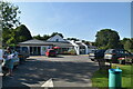
Alterations to Barham Village Hall, Valley Road
Planning permission has been granted by Canterbury City Council under application number CA//12/00752 for the “erection of single-storey extension to existing village hall to accommodate shop, post office and additional community facilities within the building, following removal of existing temporary village shop, post office and store shed”. David Anstiss’ Image shows the site as it was in 2010.
Image: © John Baker
Taken: 2 Aug 2015
0.04 miles
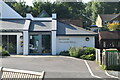
3
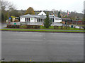
Barham?s combined shop, post office and village hall
Compared with Image, the alterations to the building have been completed.
Image: © John Baker
Taken: 6 Dec 2015
0.04 miles
6
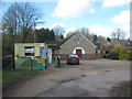
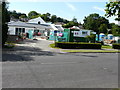
Barham Village Hall
On Valley Road in between Barham and Derringstone. The metal painted portacabin is the Nailbourne Community Store and local Post Office.
See http://www.barham-kent.org.uk/index.htm for more details on the village.
Image: © David Anstiss
Taken: 26 Mar 2010
0.05 miles
7
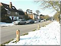
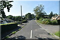
Valley Road, Barham
A number 17 bus is stationary at the bus stop on this side of the road, while across the road there is a road sign for a school, the spire of which (Barham Primary School) can be seen just beyond it.
Image: © John Baker
Taken: 11 Feb 2012
0.06 miles
8
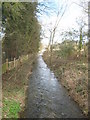
The River Nailbourne towards Barham
Seen from Grove Road bridge.
Image: © David Anstiss
Taken: 26 Mar 2010
0.06 miles
9
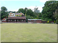
Barham Bowls Club, Valley Road
Planning permission has been granted by Canterbury City Council under application number CA//19/00028 for a “proposed single-storey side extension together with replacement roof and wall finishes, following demolition of existing shed”.
The shed is located at the far left of the bowls club.
Image: © John Baker
Taken: 1 Jul 2019
0.07 miles
10
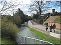
The Causeway, Derringstone
This narrow lane leads from Valley Road towards a crossroads in the village.
Beside is the River Nailbourne running through the village.
Image: © David Anstiss
Taken: 26 Mar 2010
0.08 miles