IMAGES TAKEN NEAR TO
Railway Hill, CANTERBURY, CT4 6PY
Introduction
This page details the photographs taken nearby to Railway Hill, CT4 6PY by members of the Geograph project.
The Geograph project started in 2005 with the aim of publishing, organising and preserving representative images for every square kilometre of Great Britain, Ireland and the Isle of Man.

There are currently over 7.5m images from over14,400 individuals and you can help contribute to the project by visiting https://www.geograph.org.uk
Image Map
Images are licensed for reuse under creativecommons.org/licenses/by-sa/2.0
Notes
- Clicking on the map will re-center to the selected point.
- The higher the marker number, the further away the image location is from the centre of the postcode.
Image Listing (97 Images Found)
Images are licensed for reuse under creativecommons.org/licenses/by-sa/2.0
Image
Details
Distance
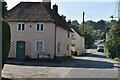
1
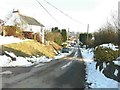
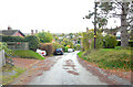
Railway Cottages, Railway Hill, Barham
In the past, a resident of No 3 Railway Cottages (the white building in this view) was Jack Heathfield, who was born in 1873. He had started employment with the South Eastern Railway in 1899 as a porter at Walmer station until he was transferred to Barham station in 1914. He retired at the age of 74 when the Elham Valley Railway closed completely. In 1960 the railway land between Railway Hill at Derringstone and Green Hill, as well as the station, was sold off by British Railways for £850 and three years later the site was cleared for a housing estate. As a tribute to Mr Heathfield, the former Station Road was renamed Heathfield Road in 1964. Further down the hill, just beyond the blue car is the Image
Image: © John Baker
Taken: 11 Feb 2012
0.02 miles
2
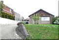
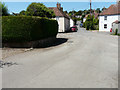
Long Meadow, Railway Hill
Planning permission has been approved by Canterbury City Council under application number CA//22/01884 for a “single-storey, part rear, part side extension following demolition of existing conservatory and detached garage”.
Image: © John Baker
Taken: 30 Oct 2022
0.02 miles
3
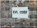
Plate on brickwork, Railway Hill, Barham
EVL stands for Elham Valley Line and refers to the railway that ran along the valley from Cheriton to Canterbury until closure in 1947. A rail bridge crossed the road at this point of which only a truncated abutment of its northeastern side remains.
Image: © John Baker
Taken: 11 Feb 2012
0.02 miles
4

Remains of railway bridge, Railway Hill, Barham
A close-up of the white Image The white building above the remains is named Railway Cottages.
Image: © John Baker
Taken: 11 Feb 2012
0.02 miles
5
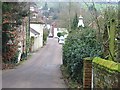
View looking west along Derringstone Street
Image: © Nick Smith
Taken: 4 Feb 2007
0.03 miles
6
Railway Hill
The road has a steep incline.
Image: © John Baker
Taken: 30 Oct 2022
0.04 miles
7
Railway Hill
This was Image in May 2020, when the Nail Bourne was flowing across the road. Now the surface is completely dry.
Image: © John Baker
Taken: 23 Jun 2020
0.04 miles
8
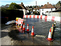
Railway Hill
Barriers have been erected to divert the floodwater of the Nail Bourne into Image and this has meant the closure of Railway Hill. An almost identical view of Image was taken in April 2020. I have never known the river to flood in consecutive years, in the twenty years I have lived in the area.
Image: © John Baker
Taken: 24 Feb 2021
0.05 miles
9
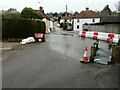
Railway Hill
It is possible to access Image, now that the barriers have been partly removed, but a slow sign has been installed to warn drivers of vehicles to proceed with care through the floodwater.
Image: © John Baker
Taken: 1 Apr 2021
0.06 miles
10
Ford Cottage and Railway Hill
Grade II listed.
Image: © N Chadwick
Taken: 8 Sep 2021
0.06 miles