IMAGES TAKEN NEAR TO
Railway Hill, CANTERBURY, CT4 6PU
Introduction
This page details the photographs taken nearby to Railway Hill, CT4 6PU by members of the Geograph project.
The Geograph project started in 2005 with the aim of publishing, organising and preserving representative images for every square kilometre of Great Britain, Ireland and the Isle of Man.

There are currently over 7.5m images from over14,400 individuals and you can help contribute to the project by visiting https://www.geograph.org.uk
Image Map
Images are licensed for reuse under creativecommons.org/licenses/by-sa/2.0
Notes
- Clicking on the map will re-center to the selected point.
- The higher the marker number, the further away the image location is from the centre of the postcode.
Image Listing (102 Images Found)
Images are licensed for reuse under creativecommons.org/licenses/by-sa/2.0
Image
Details
Distance
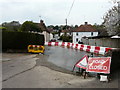
2
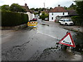
Railway Hill
It appears that the road through the flood is now passable, as the barriers, which were at the bottom of Image, have been removed.
Image: © John Baker
Taken: 13 May 2020
0.01 miles
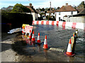
3
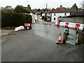
Railway Hill
It is possible to access Image, now that the barriers have been partly removed, but a slow sign has been installed to warn drivers of vehicles to proceed with care through the floodwater.
Image: © John Baker
Taken: 1 Apr 2021
0.01 miles
4
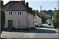
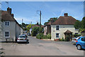
Ford Cottage and Railway Hill
Grade II listed.
Image: © N Chadwick
Taken: 8 Sep 2021
0.01 miles
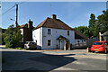
6
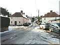
Barham crossroads
As seen from Derringstone Street looking up Railway Hill. The nearest house on the left is named Ford Cottage and is situated on the corner of South Barham Road. Across the street is Cornerways situated on the corner of The Causeway. Ice and snow covered all the roads in this view.
Image: © John Baker
Taken: 11 Feb 2012
0.01 miles
7
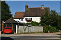
Houses on Derringstone Street
Grade II listed Ford Cottage to left on South Barham Road. Grade II listed Cornerways, the yellow building to right, on Railway Hill.
Image: © Oast House Archive
Taken: 4 Jul 2009
0.01 miles
8
Road ahead closed due to flooding
There is a ford ahead that sometimes can become dried up Image but here the depth of the Nail Bourne has made it impassable for vehicular traffic. However, the row of sandbags on the left has made it possible for pedestrians to gain access from The Causeway to South Barham Road (to the right) and Railway Hill (at the bottom of which I was standing).
Image: © John Baker
Taken: 5 Feb 2014
0.01 miles
9
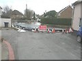
Railway Hill
Barriers have been erected to divert the floodwater of the Nail Bourne into The Causeway and this has meant the closure of Railway Hill.
This was Robin Webster’s photo of the Image in February 2020 and this was the same Image in February 2014.
Image: © John Baker
Taken: 16 Apr 2020
0.01 miles
10
Railway Hill
Barriers have been erected to divert the floodwater of the Nail Bourne into Image and this has meant the closure of Railway Hill. An almost identical view of Image was taken in April 2020. I have never known the river to flood in consecutive years, in the twenty years I have lived in the area.
Image: © John Baker
Taken: 24 Feb 2021
0.02 miles