IMAGES TAKEN NEAR TO
The Street, CANTERBURY, CT4 6NZ
Introduction
This page details the photographs taken nearby to The Street, CT4 6NZ by members of the Geograph project.
The Geograph project started in 2005 with the aim of publishing, organising and preserving representative images for every square kilometre of Great Britain, Ireland and the Isle of Man.

There are currently over 7.5m images from over14,400 individuals and you can help contribute to the project by visiting https://www.geograph.org.uk
Image Map
Images are licensed for reuse under creativecommons.org/licenses/by-sa/2.0
Notes
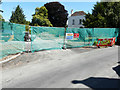
- Clicking on the map will re-center to the selected point.
- The higher the marker number, the further away the image location is from the centre of the postcode.
Image Listing (108 Images Found)
Images are licensed for reuse under creativecommons.org/licenses/by-sa/2.0
Image
Details
Distance
1
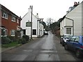
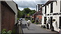
The Duke of Cumberland pub on The Street, Barham
Image: © Nick Smith
Taken: 4 Feb 2007
0.02 miles
2
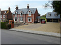
Holmwood, The Street
This was Image in July 2019.
Image: © John Baker
Taken: 16 Apr 2020
0.04 miles
3
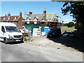
Holmwood, The Street
Planning permission has been granted by Canterbury City Council under application number CA//18/01245 “for a “proposed two-storey side and rear extensions, single-storey rear extension and detached two-storey garage”.
This was Image in April 2020.
Image: © John Baker
Taken: 4 Jul 2019
0.04 miles
4
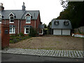
Holmwood, The Street
Planning permission has been approved by Canterbury City Council under application number CA/22/01729 for the “installation of 40 ground mounted solar photovoltaic panels alongside ancillary equipment”.
It is possible that the panels will not be visible from the road.
A similar view of Image; taken in April 2020 before the front garden had been landscaped.
Image: © John Baker
Taken: 30 Oct 2022
0.04 miles
5
The Street, Barham
Including the Duke of Cumberland pub
Image: © John Welford
Taken: 30 May 2015
0.04 miles
6
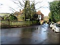
View of The Street, Barham, from junction with Rectory Lane
Image: © Nick Smith
Taken: 11 Jan 2009
0.05 miles
7
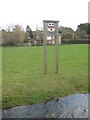
Barham Village Sign
On a large green beside The Street. In the foreground is the River Nailbourne. In the background is St. John the Baptist Church spire. The shield on the sign is a reference to the FitzUrse family who once owned Barham Court (the bears) and Canterbury (the choughs - crowlike birds on the red band). A FitzUrse was one of the knights who believed they were carrying out the wishes of the King, murdered Archbishop Thomas Becket in Canterbury in 1170.
Image: © David Anstiss
Taken: 26 Mar 2010
0.06 miles
8
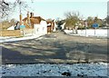
The Street, Barham
As seen from across Valley Road, with the spire of St John the Baptist church on the right of the view.
Image: © John Baker
Taken: 11 Feb 2012
0.06 miles
9
Barham House Nursing Home, The Street
It appears that a new entrance is being laid into the grounds.
Image: © John Baker
Taken: 4 Jul 2019
0.06 miles
10
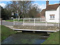
The Street bridge over the River Nailbourne
The Street leads from Valley Road (on the left) towards Barham Church and Gravel Castle. The River Nailbourne flows from Lyminge (through the Elham Valley) towards Littlebourne, where it meets the Little Stour.
Image: © David Anstiss
Taken: 26 Mar 2010
0.07 miles