IMAGES TAKEN NEAR TO
Ileden Lane, CANTERBURY, CT4 6HP
Introduction
This page details the photographs taken nearby to Ileden Lane, CT4 6HP by members of the Geograph project.
The Geograph project started in 2005 with the aim of publishing, organising and preserving representative images for every square kilometre of Great Britain, Ireland and the Isle of Man.

There are currently over 7.5m images from over14,400 individuals and you can help contribute to the project by visiting https://www.geograph.org.uk
Image Map
Images are licensed for reuse under creativecommons.org/licenses/by-sa/2.0
Notes
- Clicking on the map will re-center to the selected point.
- The higher the marker number, the further away the image location is from the centre of the postcode.
Image Listing (8 Images Found)
Images are licensed for reuse under creativecommons.org/licenses/by-sa/2.0
Image
Details
Distance
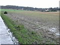
3
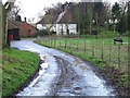
Bridleway to Ileden Farm
This hedge lined track leads from Woodlands Road, past Oxenden Wood.
This is the last section from Ileden Cottages.
Image: © David Anstiss
Taken: 5 Sep 2010
0.14 miles
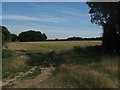
4
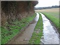
Runner on the Bridleway
The bridleway runs alongside woodland and barley field. Ileden in distance.
Image: © Oast House Archive
Taken: 18 Jul 2010
0.16 miles
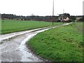
6
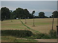
Bridleway junction near Ileden Cottages
A bridleway from Illeden Farm, heads slightly left via a tree lined track towards Oxenden Wood (in the background) and onwards to Woodland Road.
Another track leads right into Woodlands Wood and towards Cooting Down and Cooting Farm.
Image: © David Anstiss
Taken: 5 Sep 2010
0.19 miles
8
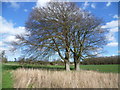
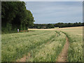
Looking towards Ileden Farm
This view is from a footpath between Gipsy Cottage and the North Downs Way. Ileden Farm is just visible to the left of the trees and Walk Wood is in the distance on the right.
Image: © Marathon
Taken: 5 Apr 2015
0.25 miles