IMAGES TAKEN NEAR TO
Bossingham, CANTERBURY, CT4 6DY
Introduction
This page details the photographs taken nearby to CT4 6DY by members of the Geograph project.
The Geograph project started in 2005 with the aim of publishing, organising and preserving representative images for every square kilometre of Great Britain, Ireland and the Isle of Man.

There are currently over 7.5m images from over14,400 individuals and you can help contribute to the project by visiting https://www.geograph.org.uk
Image Map (Loading...)


Getting Data...Please wait
Leaflet Map data © OpenStreetMap
Images are licensed for reuse under creativecommons.org/licenses/by-sa/2.0
Notes
- Clicking on the map will re-center to the selected point.
- The higher the marker number, the further away the image location is from the centre of the postcode.
Image Listing (16 Images Found)
Images are licensed for reuse under creativecommons.org/licenses/by-sa/2.0
Image
Details
Distance
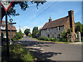
3
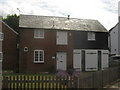
The Coach House, Bossingham
Converted Coach House, near the local pub on the Street.
Image: © David Anstiss
Taken: 18 Jul 2010
0.04 miles
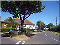
4
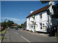
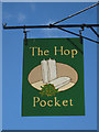
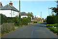
The Street, Bossingham
The Hop Pocket pub on the right. It may have closed down - there is no inn sign.
Image: © Robin Webster
Taken: 13 Oct 2018
0.04 miles
6
Hardres Court Road
At junction with The Street.
Image: © Oast House Archive
Taken: 10 Jul 2010
0.06 miles
7
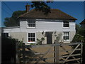
Great Bossingham Farmhouse
On Mains Hill. Near the farm.
Image: © David Anstiss
Taken: 18 Jul 2010
0.07 miles

9
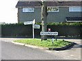
Entering Bossingham on Hardres Court Road
Image: © Nick Smith
Taken: 17 Feb 2007
0.08 miles
10
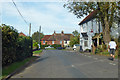
Bossingham Street, Bossingham
Towards Canterbury.
Image: © Robin Webster
Taken: 13 Oct 2018
0.09 miles