IMAGES TAKEN NEAR TO
Stone Street, CANTERBURY, CT4 6DF
Introduction
This page details the photographs taken nearby to Stone Street, CT4 6DF by members of the Geograph project.
The Geograph project started in 2005 with the aim of publishing, organising and preserving representative images for every square kilometre of Great Britain, Ireland and the Isle of Man.

There are currently over 7.5m images from over14,400 individuals and you can help contribute to the project by visiting https://www.geograph.org.uk
Image Map
Images are licensed for reuse under creativecommons.org/licenses/by-sa/2.0
Notes
- Clicking on the map will re-center to the selected point.
- The higher the marker number, the further away the image location is from the centre of the postcode.
Image Listing (6 Images Found)
Images are licensed for reuse under creativecommons.org/licenses/by-sa/2.0
Image
Details
Distance
1

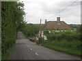
B2068 Stone Street towards Canterbury
The Roman road approaches the George Inn.
Image: © Robin Webster
Taken: 8 Jul 2018
0.07 miles
2
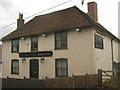
The George Inn, Stelling Minnis
This pub has recently closed, and due to the new fence around it, looks like it is being turned into a private house.
Image: © David Anstiss
Taken: 20 Jun 2010
0.08 miles
3
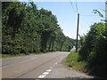
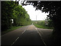
Stone Street
This long straight road is a former Roman Road.
In the background is Image, a closed pub on the route to Lympne.
Image: © David Anstiss
Taken: 20 Jun 2010
0.11 miles
4
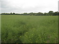
Overgrown path to Misling Lane
A path leads from Stone Street near the George Inn, through a mature oil seed rape plant field heading towards Image
Compare with Image The reverse of the path. Edards Wood is in the background.
Image: © David Anstiss
Taken: 20 Jun 2010
0.13 miles
6
Misling Lane junction on Stone Street
Stone Street heads towards Lympne. Misling Lane leads towards Maxted Street and Watsole Street.
Image: © David Anstiss
Taken: 20 Jun 2010
0.18 miles