IMAGES TAKEN NEAR TO
Petham, CANTERBURY, CT4 5QN
Introduction
This page details the photographs taken nearby to CT4 5QN by members of the Geograph project.
The Geograph project started in 2005 with the aim of publishing, organising and preserving representative images for every square kilometre of Great Britain, Ireland and the Isle of Man.

There are currently over 7.5m images from over14,400 individuals and you can help contribute to the project by visiting https://www.geograph.org.uk
Image Map (Loading...)


Getting Data...Please wait
Leaflet Map data © OpenStreetMap
Images are licensed for reuse under creativecommons.org/licenses/by-sa/2.0
Notes
- Clicking on the map will re-center to the selected point.
- The higher the marker number, the further away the image location is from the centre of the postcode.
Image Listing (33 Images Found)
Images are licensed for reuse under creativecommons.org/licenses/by-sa/2.0
Image
Details
Distance
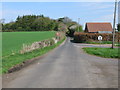
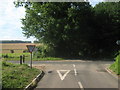
3
Redhouse Lane junction with Chartham Downs Road
Image: © Nick Smith
Taken: 10 Apr 2009
0.08 miles
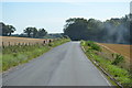
6
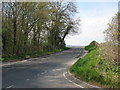
Chartham Downs Road from junction with Iffin Lane
Image: © Nick Smith
Taken: 10 Apr 2009
0.10 miles
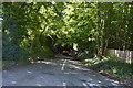
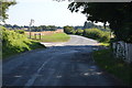
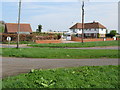
8
Crossroads on Chartham Downs Road
Iffin Lane from Canterbury becomes Redhouse Lane leading towards the B2068 Stone Street. Chartham Downs Road leads left towards Street End, or right towards Chartham Downs.
Image: © David Anstiss
Taken: 18 Jul 2010
0.10 miles
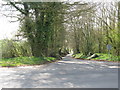
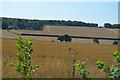
9
Harmansole Cottage between the Stone Street and Redhouse Lane
Image: © Nick Smith
Taken: 10 Apr 2009
0.13 miles