IMAGES TAKEN NEAR TO
Coldharbour Lane, CANTERBURY, CT4 5HL
Introduction
This page details the photographs taken nearby to Coldharbour Lane, CT4 5HL by members of the Geograph project.
The Geograph project started in 2005 with the aim of publishing, organising and preserving representative images for every square kilometre of Great Britain, Ireland and the Isle of Man.

There are currently over 7.5m images from over14,400 individuals and you can help contribute to the project by visiting https://www.geograph.org.uk
Image Map (Loading...)


Getting Data...Please wait
Leaflet Map data © OpenStreetMap
Images are licensed for reuse under creativecommons.org/licenses/by-sa/2.0
Notes
- Clicking on the map will re-center to the selected point.
- The higher the marker number, the further away the image location is from the centre of the postcode.
Image Listing (25 Images Found)
Images are licensed for reuse under creativecommons.org/licenses/by-sa/2.0
Image
Details
Distance
1
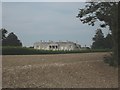
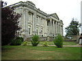
Higham Park
As seen from the North Downs Way (long distance path)
This historic house near Bridge had been closed and falling into ruin. Until it was bought in 1995 and the house and gardens have been going under renovation.
It is open to the public. Has an amazing display of daffodils.
See http://www.gardens-to-go.org.uk/higham_park.htm for more details about the house and the gardens.
Image: © David Anstiss
Taken: 5 Sep 2010
0.11 miles
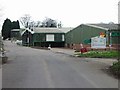
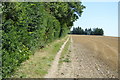
8
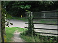
The North Downs Way crosses Higham Park access road
The long distance path from Patrixbourne leads across the road and onto a bridleway heading towards Coldharbour Lane.
The access road leads left, towards the Historic House and Garden, or right Image over the A2 dual carriageway leading to Bridge.
Image: © David Anstiss
Taken: 5 Sep 2010
0.19 miles
9
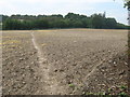
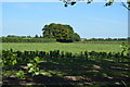
North Downs Way crosses a field near Higham Park
The long distance path leads from Coldharbour Lane, towards the access road to the historic house near Bridge, before heading towards Patrixbourne.
Image: © David Anstiss
Taken: 5 Sep 2010
0.19 miles