IMAGES TAKEN NEAR TO
Bekesbourne, CANTERBURY, CT4 5EA
Introduction
This page details the photographs taken nearby to CT4 5EA by members of the Geograph project.
The Geograph project started in 2005 with the aim of publishing, organising and preserving representative images for every square kilometre of Great Britain, Ireland and the Isle of Man.

There are currently over 7.5m images from over14,400 individuals and you can help contribute to the project by visiting https://www.geograph.org.uk
Image Map
Images are licensed for reuse under creativecommons.org/licenses/by-sa/2.0
Notes
- Clicking on the map will re-center to the selected point.
- The higher the marker number, the further away the image location is from the centre of the postcode.
Image Listing (4 Images Found)
Images are licensed for reuse under creativecommons.org/licenses/by-sa/2.0
Image
Details
Distance
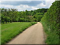
2
Footpath towards Conduit Wood
This path leads from Bekesbourne Lane, beside a orchard, then it meets another path and heads through the polytunnels (and strawberries) towards another footpath between Conduit Wood (in the background) and Canterbury Road.
Image: © David Anstiss
Taken: 5 Sep 2010
0.15 miles
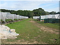
3
Polytunnels near Bekesbourne
A footpath leads up from Bekesbourne Hill.
Under the tunnels strawberries are still growing.
Image: © David Anstiss
Taken: 5 Sep 2010
0.22 miles
4
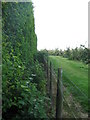
Footpath to Bekesbourne Lane
A path from Conduit Wood, leads through a strawberry and polytunnel farm, and then along this hedge towards the lane. On the right is an apple orchard.
Image: © David Anstiss
Taken: 5 Sep 2010
0.23 miles