IMAGES TAKEN NEAR TO
Island Road, CANTERBURY, CT3 4HD
Introduction
This page details the photographs taken nearby to Island Road, CT3 4HD by members of the Geograph project.
The Geograph project started in 2005 with the aim of publishing, organising and preserving representative images for every square kilometre of Great Britain, Ireland and the Isle of Man.

There are currently over 7.5m images from over14,400 individuals and you can help contribute to the project by visiting https://www.geograph.org.uk
Image Map
Images are licensed for reuse under creativecommons.org/licenses/by-sa/2.0
Notes
- Clicking on the map will re-center to the selected point.
- The higher the marker number, the further away the image location is from the centre of the postcode.
Image Listing (34 Images Found)
Images are licensed for reuse under creativecommons.org/licenses/by-sa/2.0
Image
Details
Distance
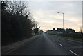
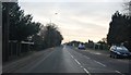
2
Canterbury goods vehicle testing station
On the A28 at Hersden.
Image: © Bill Boaden
Taken: 28 Jun 2012
0.06 miles
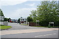
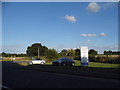
4
Entrance to the Canterbury vehicle testing station
Image: © David Howard
Taken: 31 Jul 2016
0.08 miles
8
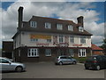
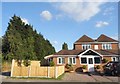
Chopsticks Restaurant
Converted Pub on the A28 Island Road near Hersden.
This was 'The Black Horse' built in 1931. When Hersden was Chislet Colliery Village.
Image: © David Anstiss
Taken: 11 Jul 2010
0.11 miles
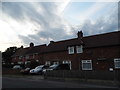
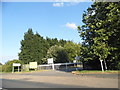
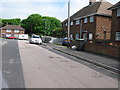
10

St. Dunstans Catholic Church
On East View.
Image: © David Anstiss
Taken: 11 Jul 2010
0.12 miles