IMAGES TAKEN NEAR TO
Blackthorn Road, CANTERBURY, CT3 4GB
Introduction
This page details the photographs taken nearby to Blackthorn Road, CT3 4GB by members of the Geograph project.
The Geograph project started in 2005 with the aim of publishing, organising and preserving representative images for every square kilometre of Great Britain, Ireland and the Isle of Man.

There are currently over 7.5m images from over14,400 individuals and you can help contribute to the project by visiting https://www.geograph.org.uk
Image Map
Images are licensed for reuse under creativecommons.org/licenses/by-sa/2.0
Notes
- Clicking on the map will re-center to the selected point.
- The higher the marker number, the further away the image location is from the centre of the postcode.
Image Listing (37 Images Found)
Images are licensed for reuse under creativecommons.org/licenses/by-sa/2.0
Image
Details
Distance
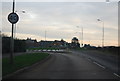
1
Roundabout on Blackthorn Road
Crossing Acacia Drive.
Image: © Oast House Archive
Taken: 24 Jun 2010
0.04 miles
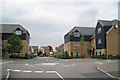
2
Meadow View, Blackthorn Road
Meadow View is a care home with 60 en-suite rooms
https://www.sanctuary-care.co.uk/meadow-view-residential-home Almost a year ago, the view was of the Image, although there is still work to be carried out before the opening date of the building.
Image: © John Baker
Taken: 5 Aug 2015
0.07 miles
3
Erection of a care home
Seen from Blackthorn Road, planning permission has been granted by Canterbury City Council under application number CA/13/00738 for the “variation of condition 11 (approved drawings) of planning application CA/12/001806 for the erection of a 60-bed care home with parking, landscaping and associated works. Revisions in respect of the footprint and layout of the application scheme”. The site is described as "land at Blackthorn Road/Island Road, Sturry", although friends who live in this road would disagree as their postal address is Hersden. The care home was given the name of Image upon completion.
Image: © John Baker
Taken: 20 Aug 2014
0.08 miles
4
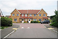
Houses on The Avenue
A terrace of three houses at junction with Larch Close (to right).
Image: © Oast House Archive
Taken: 24 Jun 2010
0.08 miles
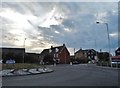
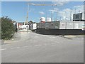
6
Roundabout, Island Road
A Redrow advertisement board is for a development, which has been named The Hoplands; it is being built on land, which was once Image and Hoplands Road to the right of newly built houses, leads into it.
Planning permission has been granted by Canterbury City Council under application number CA//16/00404 for an “outline planning application for a neighbourhood extension for the creation of up to 250 houses including affordable housing, neighbourhood centre (comprising Class A1 food store (400sq.m), Class D1 medical centre (380sq.m), Class D1 dentist (150sq.m), Class A1 pharmacy (150sq.m), Class D1 nursery (120sq.m) and Class A1 convenience retail (360sq.m)), commercial estate (comprising Class B1 business floor space (up to 5572sq.m), Class D1 apprenticeship centre (616sq.m) and Class D1/D2 community building (up to 672sq.m)), parish parkland and associated access, parking, amenity space and landscaping.
This was the same Image in June 2020.
Image: © John Baker
Taken: 18 Jul 2021
0.10 miles
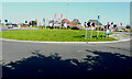
7
Roundabout, Island Road
A Redrow advertisement board is for a development, which has been named The Hoplands; it is being built on land, which was once Image and the road to the right leads into it.
Planning permission has been granted by Canterbury City Council under application number CA//16/00404 for an “outline planning application for a neighbourhood extension for the creation of up to 250 houses including affordable housing, neighbourhood centre (comprising Class A1 food store (400sq.m), Class D1 medical centre (380sq.m), Class D1 dentist (150sq.m), Class A1 pharmacy (150sq.m), Class D1 nursery (120sq.m) and Class A1 convenience retail (360sq.m)), commercial estate (comprising Class B1 business floor space (up to 5572sq.m), Class D1 apprenticeship centre (616sq.m) and Class D1/D2 community building (up to 672sq.m)), parish parkland and associated access, parking, amenity space and landscaping.
Image: © John Baker
Taken: 14 Jun 2020
0.10 miles
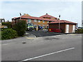
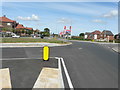
8
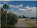
Hersden Village Sign
On the A28 Island Road, close to the roundabout with Blackthorn Road.
The sign was erected by Sturry Parish Council in partnership with Kent County Council.
Image: © David Anstiss
Taken: 11 Jul 2010
0.10 miles