IMAGES TAKEN NEAR TO
Pond View Close, CT3 4FP
Introduction
This page details the photographs taken nearby to Pond View Close, CT3 4FP by members of the Geograph project.
The Geograph project started in 2005 with the aim of publishing, organising and preserving representative images for every square kilometre of Great Britain, Ireland and the Isle of Man.

There are currently over 7.5m images from over14,400 individuals and you can help contribute to the project by visiting https://www.geograph.org.uk
Image Map
Images are licensed for reuse under creativecommons.org/licenses/by-sa/2.0
Notes
- Clicking on the map will re-center to the selected point.
- The higher the marker number, the further away the image location is from the centre of the postcode.
Image Listing (35 Images Found)
Images are licensed for reuse under creativecommons.org/licenses/by-sa/2.0
Image
Details
Distance
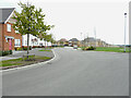
1
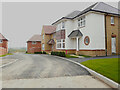
Lakehill Road
Part of a housing estate called The Hoplands for which planning permission has been granted by Canterbury City Council under application number CA//16/00404.
Image: © John Baker
Taken: 30 Apr 2023
0.01 miles
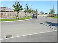
2
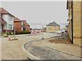
Unnamed Road
Part of a housing estate called The Hoplands for which planning permission has been granted by Canterbury City Council under application number CA//16/00404.
Image: © John Baker
Taken: 30 Apr 2023
0.03 miles
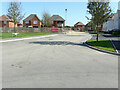
3
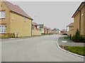
Lakehill Road
Part of a housing estate called The Hoplands for which planning permission has been granted by Canterbury City Council under application number CA//16/00404.
Image: © John Baker
Taken: 30 Apr 2023
0.06 miles
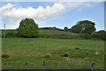
4

Snow covered field near Hersden
Another snow filled night has covered most of Northern Kent.
The dense clouds obscure distances past the hills of Stodmarsh in the distance.
Image: © David Anstiss
Taken: 22 Mar 2013
0.08 miles
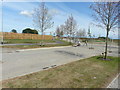
6
Longwall Lane
Part of a housing estate called The Hoplands for which planning permission has been granted by Canterbury City Council under application number CA//16/00404. An “outline planning application for a neighbourhood extension for the creation of up to 250 houses including affordable housing, neighbourhood centre (comprising Class A1 food store (400sq.m), Class D1 medical centre (380sq.m), Class D1 dentist (150sq.m), Class A1 pharmacy (150sq.m), Class D1 nursery (120sq.m) and Class A1 convenience retail (360sq.m)), commercial estate (comprising Class B1 business floorspace (up to 5572sq.m), Class D1 apprenticeship centre (616sq.m) and Class D1/D2 community building (up to 672sq.m)), parish parkland and associated access, parking, amenity space and landscaping”.
A similar view of Image was taken in July 2021.
Image: © John Baker
Taken: 18 Sep 2022
0.12 miles
7
Longwall Lane
Longwall Lane is a road on a development, which has been named The Hoplands; it has been built on land, which was once Image
Planning permission has been granted by Canterbury City Council under application number CA//16/00404 for an “outline planning application for a neighbourhood extension for the creation of up to 250 houses including affordable housing, neighbourhood centre (comprising Class A1 food store (400sq.m), Class D1 medical centre (380sq.m), Class D1 dentist (150sq.m), Class A1 pharmacy (150sq.m), Class D1 nursery (120sq.m) and Class A1 convenience retail (360sq.m)), commercial estate (comprising Class B1 business floor space (up to 5572sq.m), Class D1 apprenticeship centre (616sq.m) and Class D1/D2 community building (up to 672sq.m)), parish parkland and associated access, parking, amenity space and landscaping.
Image: © John Baker
Taken: 18 Jul 2021
0.12 miles
8
Hoplands Road
Hoplands Road is a road on a development, which has been named The Hoplands; it has been built on land, which was once Image
Planning permission has been granted by Canterbury City Council under application number CA//16/00404 for an “outline planning application for a neighbourhood extension for the creation of up to 250 houses including affordable housing, neighbourhood centre (comprising Class A1 food store (400sq.m), Class D1 medical centre (380sq.m), Class D1 dentist (150sq.m), Class A1 pharmacy (150sq.m), Class D1 nursery (120sq.m) and Class A1 convenience retail (360sq.m)), commercial estate (comprising Class B1 business floor space (up to 5572sq.m), Class D1 apprenticeship centre (616sq.m) and Class D1/D2 community building (up to 672sq.m)), parish parkland and associated access, parking, amenity space and landscaping.
Image: © John Baker
Taken: 18 Jul 2021
0.12 miles
9
Hoplands Road
Hoplands Road is a road on a development, which has been named The Hoplands; it has been built on land, which was once Image
Planning permission has been granted by Canterbury City Council under application number CA//16/00404 for an “outline planning application for a neighbourhood extension for the creation of up to 250 houses including affordable housing, neighbourhood centre (comprising Class A1 food store (400sq.m), Class D1 medical centre (380sq.m), Class D1 dentist (150sq.m), Class A1 pharmacy (150sq.m), Class D1 nursery (120sq.m) and Class A1 convenience retail (360sq.m)), commercial estate (comprising Class B1 business floor space (up to 5572sq.m), Class D1 apprenticeship centre (616sq.m) and Class D1/D2 community building (up to 672sq.m)), parish parkland and associated access, parking, amenity space and landscaping.
Image: © John Baker
Taken: 14 Jun 2020
0.15 miles
10
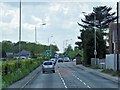
A28, Island Road, Hersden
Between Sarre and Canterbury, the A28 follows the line of an early Roman road.
Image: © David Dixon
Taken: 16 May 2013
0.16 miles