IMAGES TAKEN NEAR TO
Island Road, CANTERBURY, CT3 4DG
Introduction
This page details the photographs taken nearby to Island Road, CT3 4DG by members of the Geograph project.
The Geograph project started in 2005 with the aim of publishing, organising and preserving representative images for every square kilometre of Great Britain, Ireland and the Isle of Man.

There are currently over 7.5m images from over14,400 individuals and you can help contribute to the project by visiting https://www.geograph.org.uk
Image Map
Images are licensed for reuse under creativecommons.org/licenses/by-sa/2.0
Notes
- Clicking on the map will re-center to the selected point.
- The higher the marker number, the further away the image location is from the centre of the postcode.
Image Listing (66 Images Found)
Images are licensed for reuse under creativecommons.org/licenses/by-sa/2.0
Image
Details
Distance
2

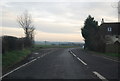
Footpath towards Puddledock Wood
This path leads from the A28 Island Road towards a small triangle of wood near Upstreet.
Image: © David Anstiss
Taken: 11 Jul 2010
0.04 miles
3
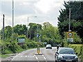
Island Road, Upstreet
The A28 entering the village of Upstreet.
Image: © David Dixon
Taken: 16 May 2013
0.06 miles
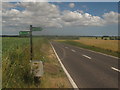
4
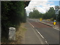
Milestone on Island Road
This milestone is on the outskirts of Upstreet, on the A28 heading towards Sarre and the Isle of Thanet.
On the reverse is London 42.
Image: © David Anstiss
Taken: 11 Jul 2010
0.07 miles
5
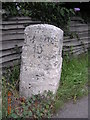
Old Milestone by the A28, Island Road, Upstreet
Ramsgate limestone diamond by the A28, in parish of Chislet (Canterbury District), Island Road, Upstreet, by No.145 on East edge of village, in grass between path and wooden fence and hedge to bungalow.
Inscription reads:-
: RAMSGATE / 10 : : LONDON / 62 :
Kent HER.
HER Number: TR 26 SW 195 https://www.heritagegateway.org.uk/Gateway/Results_Single.aspx?uid=MKE78174&resourceID=1005
Surveyed
Milestone Society National ID: KE_RGCY10
Image: © Alan Rosevear
Taken: 9 Aug 2004
0.07 miles

7

Saxon Shore Way to Grove Ferry
The long distance path (and Wantsum Walk - another long distance path) leads from Chislet, then over the A28 Island Road, heading towards Grove Ferry Hill (near the railway and public house), before heading towards West Stourmouth.
Image: © David Anstiss
Taken: 11 Jul 2010
0.08 miles
8
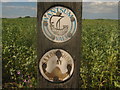
Saxon Shore Way and Wantsum Walk Markers
On a post beside the A28 Island Road.
Image: © David Anstiss
Taken: 11 Jul 2010
0.09 miles
9
The Saxon Shore Way crosses the A28 Island Road
The long distance path heads left towards Boyden Gate and Reculver, it also heads right across the road towards Grove Ferry and West Stourmouth.
The A28 heads from Canterbury towards Sarre and the Isle of Thanet.
It is also used by the Wantsum Walk (another long distance path)
Image: © David Anstiss
Taken: 11 Jul 2010
0.10 miles
10

Saxon Shore Way to Island Road
The long distance path (and Wantsum Walk - another long distance path) leads from Grove Ferry Hill (near the railway and public house),through a field of beans, heading towards the A28 before heading towards Chislet.
Compare with Image, taken reverse view , last year!
Image: © David Anstiss
Taken: 30 May 2011
0.11 miles