IMAGES TAKEN NEAR TO
Island Road, CANTERBURY, CT3 4DF
Introduction
This page details the photographs taken nearby to Island Road, CT3 4DF by members of the Geograph project.
The Geograph project started in 2005 with the aim of publishing, organising and preserving representative images for every square kilometre of Great Britain, Ireland and the Isle of Man.

There are currently over 7.5m images from over14,400 individuals and you can help contribute to the project by visiting https://www.geograph.org.uk
Image Map
Images are licensed for reuse under creativecommons.org/licenses/by-sa/2.0
Notes
- Clicking on the map will re-center to the selected point.
- The higher the marker number, the further away the image location is from the centre of the postcode.
Image Listing (15 Images Found)
Images are licensed for reuse under creativecommons.org/licenses/by-sa/2.0
Image
Details
Distance
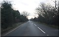
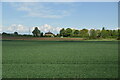
2
Island Road, Wall End
The level pasture fields on the western and southern sides of Sarre are intersected by many drainage channels of the former Wantsum Channel. The A28 road crosses this drained land on a low causeway known as Sarre Wall.
Image: © David Dixon
Taken: 16 May 2013
0.05 miles


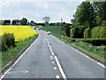
7

Looking NW across the Great Stour
Looking towards the A28 Island Road between Upstreet and Sarre which follows the tree line on the horizon.
Image: © Nick Smith
Taken: 12 Oct 2008
0.16 miles
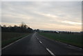
9

Looking SW along the A28 Island Road
In the direction of Upstreet, Sturry and Canterbury.
Image: © Nick Smith
Taken: 12 Oct 2008
0.19 miles