IMAGES TAKEN NEAR TO
Stodmarsh, CANTERBURY, CT3 4BE
Introduction
This page details the photographs taken nearby to CT3 4BE by members of the Geograph project.
The Geograph project started in 2005 with the aim of publishing, organising and preserving representative images for every square kilometre of Great Britain, Ireland and the Isle of Man.

There are currently over 7.5m images from over14,400 individuals and you can help contribute to the project by visiting https://www.geograph.org.uk
Image Map
Images are licensed for reuse under creativecommons.org/licenses/by-sa/2.0
Notes
- Clicking on the map will re-center to the selected point.
- The higher the marker number, the further away the image location is from the centre of the postcode.
Image Listing (43 Images Found)
Images are licensed for reuse under creativecommons.org/licenses/by-sa/2.0
Image
Details
Distance
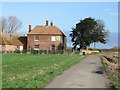
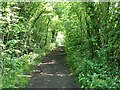
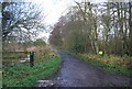
2
View of farm track and Undertrees Farm, Stodmarsh.
Image: © Nick Smith
Taken: 21 Jan 2007
0.03 miles
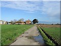
3
Dyer's Rocket, Stodmarsh National Nature Reserve
Also known as weld, Reseda luteola is a common native biennial. It provides one of the most ancient dyes and used to be cultivated for dying fabrics bright yellow. In the background is one of the pools on the reserve.
Image: © pam fray
Taken: 28 Aug 2018
0.06 miles
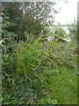
4
Boardwalk, Stodmarsh Nature Reserve
Stodmarsh National Nature Reserve covers 241 hectares of wetland and is characterised by extensive reedbeds, lakes and associated bird populations. It is a Special Protection Area and also a Wetland of International Importance under the Ramsar Convention. The reserve is managed by Natural England as a National Nature Reserve.
Image: © N Chadwick
Taken: 12 Dec 2009
0.08 miles
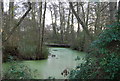
5

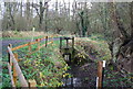
A ditch and sluice gate on Stodmarsh National Nature Reserve
The earliest recorded use of the land which now makes up the National Nature Reserve of Stodmarsh was by Augustinian monks during medieval times. The monks dug ditches to bring the mineral-rich river floodwater onto the meadows to flood them and make the grass more productive. The marsh was used for grazing mares in foal and at this time was known as Stud-marsh.
In the early 18th century a flood defence barrier, the Lampen Wall, was constructed by Flemish engineers to prevent excessive flooding in the Grove Ferry area. This more efficient drainage of the valley was reversed by the opening of Chislet Colliery at the start of the 20th century. The land subsided due to the underground working and became waterlogged.
By the 1930s small lagoons had formed in the meadows. Reed beds then developed, spreading from the river banks to cover the wetter areas. The marsh was then used for wildfowling. The land was notified as a Site of Special Scientific Interest in 1951 and became a National Nature Reserve in 1968.
Image: © Marathon
Taken: 1 May 2016
0.12 miles
6
Path in Stodmarsh Nature Reserve
Stodmarsh National Nature Reserve covers 241 hectares of wetland and is characterised by extensive reedbeds, lakes and associated bird populations. It is a Special Protection Area and also a Wetland of International Importance under the Ramsar Convention. The reserve is managed by English Nature as a National Nature Reserve.
Image: © N Chadwick
Taken: 12 Dec 2009
0.12 miles
8
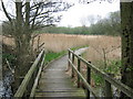
Boardwalk on Stour Valley Walk in Stodmarsh Nature Reserve
This boardwalk on the long distance footpath leads to the Lampen Wall beside the Lampen Stream (a 17th Century sea defence wall beside a dyke) allowing access to the Wantsum Marshes. It also leads to the Lake Hide within the reserve.
Image: © David Anstiss
Taken: 12 Apr 2009
0.13 miles
9
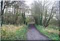
Wooded walk through Stodmarsh nature reserve
Image: © Nick Smith
Taken: 2 Jun 2007
0.13 miles
10
Stour Valley Walk in Stodmarsh Nature Reserve
Stodmarsh National Nature Reserve covers 241 hectares of wetland and is characterised by extensive reedbeds, lakes and associated bird populations. It is a Special Protection Area and also a Wetland of International Importance under the Ramsar Convention. The reserve is managed by English Nature as a National Nature Reserve.
Image: © N Chadwick
Taken: 12 Dec 2009
0.13 miles