IMAGES TAKEN NEAR TO
Fife Way, CANTERBURY, CT3 3GZ
Introduction
This page details the photographs taken nearby to Fife Way, CT3 3GZ by members of the Geograph project.
The Geograph project started in 2005 with the aim of publishing, organising and preserving representative images for every square kilometre of Great Britain, Ireland and the Isle of Man.

There are currently over 7.5m images from over14,400 individuals and you can help contribute to the project by visiting https://www.geograph.org.uk
Image Map
Images are licensed for reuse under creativecommons.org/licenses/by-sa/2.0
Notes
- Clicking on the map will re-center to the selected point.
- The higher the marker number, the further away the image location is from the centre of the postcode.
Image Listing (172 Images Found)
Images are licensed for reuse under creativecommons.org/licenses/by-sa/2.0
Image
Details
Distance
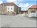
1
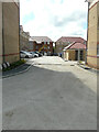
Fife Way
The development is part of the Aylesham Garden Village project http://www.ayleshamgardenvillage.co.uk/
Image: © John Baker
Taken: 4 Jul 2021
0.01 miles
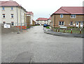
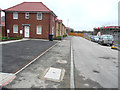
2
Winder Place
Note the sign, affixed to the fence panel on the right, pointing to Image The development is part of the Aylesham Garden Village project http://www.ayleshamgardenvillage.co.uk/
Image: © John Baker
Taken: 4 Jul 2021
0.02 miles
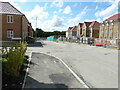
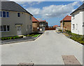
3
Winder Place
This was a similar view of Image in July 2021. The development is part of the Aylesham Garden Village project http://www.ayleshamgardenvillage.co.uk/
Image: © John Baker
Taken: 12 Dec 2021
0.02 miles
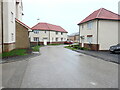
4
Houses under construction
As seen from Winder Place. The nearer block of houses can also be seen in this view of Image and likewise the vehicles. The development is part of the Aylesham Garden Village project http://www.ayleshamgardenvillage.co.uk/
Image: © John Baker
Taken: 10 Mar 2020
0.03 miles
5
Temporary access to Fife Way
There is a noticeboard, with this information about access, affixed to a shed, at the bend in the road. The development is part of the Aylesham Garden Village project http://www.ayleshamgardenvillage.co.uk/
The road has since been named Matlock Close.
Image: © John Baker
Taken: 4 Jul 2021
0.03 miles
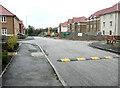
6
Matlock Close
This was Matlock Close, when it was a Image in July 2021. The development is part of the Aylesham Garden Village project http://www.ayleshamgardenvillage.co.uk/
Image: © John Baker
Taken: 12 Dec 2021
0.03 miles
7
Goldthorpe Drive
This was Image looking in the other direction in March 2020. The development is part of the Aylesham Garden Village project http://www.ayleshamgardenvillage.co.uk/
Image: © John Baker
Taken: 5 Jul 2020
0.03 miles
8
Matlock Close
This view of Image shows the house immediately ahead, at the bend in the road. The development is part of the Aylesham Garden Village project http://www.ayleshamgardenvillage.co.uk/
Image: © John Baker
Taken: 12 Dec 2021
0.04 miles
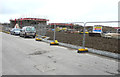
9
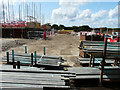
Building site
The view was taken through a hole in the hoarding along Winder Place. The development is part of the Aylesham Garden Village project http://www.ayleshamgardenvillage.co.uk/
Image: © John Baker
Taken: 18 Aug 2019
0.04 miles
10
Winder Place
The road leads to Image The development is part of the Aylesham Garden Village project http://www.ayleshamgardenvillage.co.uk/ These were the same houses in Image in December 2019.
Image: © John Baker
Taken: 10 Mar 2020
0.04 miles