IMAGES TAKEN NEAR TO
Overland, CANTERBURY, CT3 2LF
Introduction
This page details the photographs taken nearby to Overland, CT3 2LF by members of the Geograph project.
The Geograph project started in 2005 with the aim of publishing, organising and preserving representative images for every square kilometre of Great Britain, Ireland and the Isle of Man.

There are currently over 7.5m images from over14,400 individuals and you can help contribute to the project by visiting https://www.geograph.org.uk
Image Map
Images are licensed for reuse under creativecommons.org/licenses/by-sa/2.0
Notes
- Clicking on the map will re-center to the selected point.
- The higher the marker number, the further away the image location is from the centre of the postcode.
Image Listing (17 Images Found)
Images are licensed for reuse under creativecommons.org/licenses/by-sa/2.0
Image
Details
Distance
1
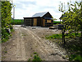
Barn conversion, Overland Lane
Planning permission was granted by Dover District Council under application number DOV/16/00874 for the “prior approval for the change of use of agricultural building to dwelling house and associated operational development”. The site was described as The Black Barn, Hoaden Court Farm. The view was taken from a footpath that runs through a cherry orchard. This is the Image from the road.
Image: © John Baker
Taken: 16 Apr 2017
0.04 miles
2
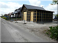
Barn conversion, Overland Lane
Planning permission was granted by Dover District Council under application number DOV/16/00874 for the “prior approval for the change of use of agricultural building to dwelling house and associated operational development”. The site was described as The Black Barn, Hoaden Court Farm. This is the Image from the back.
Image: © John Baker
Taken: 16 Apr 2017
0.04 miles
3
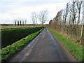
Looking NW along Overland Lane from Overland Farm.
Image: © Nick Smith
Taken: 20 Jan 2007
0.05 miles
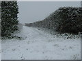
4
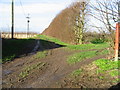
Footpath along orchard boundary, Overland Lane.
Image: © Nick Smith
Taken: 20 Jan 2007
0.08 miles
9
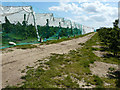
Netting over cherry trees
To prevent damage to the fruit by birds.
Image: © John Baker
Taken: 7 Jun 2015
0.18 miles
10
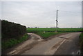
Footpath junction near Hoaden Farm
A footpath leads straight on from Hoaden Lane past Hoaden Court Farm towards Sheerwater Road. Another footpath heads right along the hedge towards Overland Farm, from Hoaden Farm.
Image: © David Anstiss
Taken: 29 Nov 2010
0.19 miles