IMAGES TAKEN NEAR TO
Chilton Field, CANTERBURY, CT3 2EY
Introduction
This page details the photographs taken nearby to Chilton Field, CT3 2EY by members of the Geograph project.
The Geograph project started in 2005 with the aim of publishing, organising and preserving representative images for every square kilometre of Great Britain, Ireland and the Isle of Man.

There are currently over 7.5m images from over14,400 individuals and you can help contribute to the project by visiting https://www.geograph.org.uk
Image Map
Images are licensed for reuse under creativecommons.org/licenses/by-sa/2.0
Notes
- Clicking on the map will re-center to the selected point.
- The higher the marker number, the further away the image location is from the centre of the postcode.
Image Listing (86 Images Found)
Images are licensed for reuse under creativecommons.org/licenses/by-sa/2.0
Image
Details
Distance
6

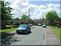
Ash Library
In an extension built on to Image, on Queens Road.
In the background is a free car park for the Hall, library and village.
Image: © David Anstiss
Taken: 16 Jan 2011
0.09 miles
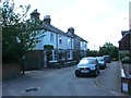
7

Ash Village Hall
On Queens Road. In the background is the spire of St. Nicholas Church.
The single floor extension, in the foreground is Image
Image: © David Anstiss
Taken: 16 Jan 2011
0.09 miles
9
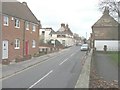
The Street, Ash from St Nicholas' churchyard
On the left is the former Lagaan Restaurant (number 60) that was gutted by fire on 17 January 2009 as reported in these links http://www.thisiskent.co.uk/Investigation-Indian-restaurant/story-12000873-detail/story.html and http://news.bbc.co.uk/1/hi/england/kent/7835051.stm It is now to be rebuilt. Planning permission has been granted by Dover District Council under application number DOV/12/00678 for “change of use, conversion and rebuilding of existing building to form two semi-detached dwellings and creation of a detached car port”.
Image: © John Baker
Taken: 30 Dec 2012
0.11 miles
10
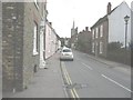
The Street, Ash
With the tower and steeple of St Nicholas' church in the distance.
Image: © John Baker
Taken: 30 Dec 2012
0.11 miles