IMAGES TAKEN NEAR TO
Cop Street Road, CANTERBURY, CT3 2DN
Introduction
This page details the photographs taken nearby to Cop Street Road, CT3 2DN by members of the Geograph project.
The Geograph project started in 2005 with the aim of publishing, organising and preserving representative images for every square kilometre of Great Britain, Ireland and the Isle of Man.

There are currently over 7.5m images from over14,400 individuals and you can help contribute to the project by visiting https://www.geograph.org.uk
Image Map
Images are licensed for reuse under creativecommons.org/licenses/by-sa/2.0
Notes
- Clicking on the map will re-center to the selected point.
- The higher the marker number, the further away the image location is from the centre of the postcode.
Image Listing (9 Images Found)
Images are licensed for reuse under creativecommons.org/licenses/by-sa/2.0
Image
Details
Distance
2
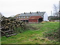
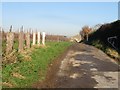
Farm log supply, Upper Goldstone
Taken from the footpath which runs through the farm.
Image: © Nick Smith
Taken: 1 Jan 2008
0.02 miles
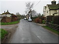
3
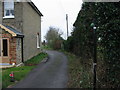
Looking north-northeast along The Row
The telephone box, to the right of the footpath signpost, had been filled by a creeper. There was a notice, on the door, to inform the public that the box was going to be removed.
Image: © John Baker
Taken: 2 Oct 2016
0.04 miles
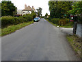
5
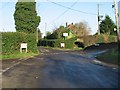
Three way junction
Roads to Lower Goldstone (straight on) Paramour Street (left) and Richborough (right).
Image: © Nick Smith
Taken: 12 Dec 2007
0.06 miles
6
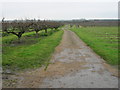
Footpath and farm track through the orchards
One footpath continues along the length of the farm track, another turns right at the point in the centre of the picture where there is a slight kink in the track.
Image: © Nick Smith
Taken: 1 Jan 2008
0.09 miles
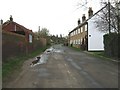
8
Start of the footpath to Upper Goldstone
The path passes along the driveway of the house then passes into the orchards via a gap in the fence.
Image: © Nick Smith
Taken: 1 Jan 2008
0.19 miles
9
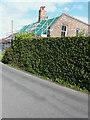
Alterations to Forge House, Cop Street
Planning permission has been granted by Dover District Council under application number DOV/15/00937 for the “erection of a two storey rear extension, a front dormer roof extension and installation of two roof lights to front roof slope”.
Image: © John Baker
Taken: 2 Oct 2016
0.24 miles