IMAGES TAKEN NEAR TO
Bekesbourne Lane, CANTERBURY, CT3 1XH
Introduction
This page details the photographs taken nearby to Bekesbourne Lane, CT3 1XH by members of the Geograph project.
The Geograph project started in 2005 with the aim of publishing, organising and preserving representative images for every square kilometre of Great Britain, Ireland and the Isle of Man.

There are currently over 7.5m images from over14,400 individuals and you can help contribute to the project by visiting https://www.geograph.org.uk
Image Map
Images are licensed for reuse under creativecommons.org/licenses/by-sa/2.0
Notes
- Clicking on the map will re-center to the selected point.
- The higher the marker number, the further away the image location is from the centre of the postcode.
Image Listing (25 Images Found)
Images are licensed for reuse under creativecommons.org/licenses/by-sa/2.0
Image
Details
Distance
1
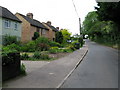
The rear of Lackenden Cottages from near Well Chapel
Image: © Nick Smith
Taken: 22 Sep 2009
0.04 miles
2
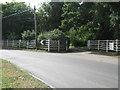
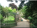
Howletts Gate 2
On Bekesbourne Lane. This private works entrance leads to the animal attraction.
Image: © David Anstiss
Taken: 15 Aug 2010
0.05 miles
3
Looking NE along Bekesbourne Lane past Lackenden Cottages
Image: © Nick Smith
Taken: 4 Jun 2009
0.05 miles
5
Path in Howletts Animal Park
A wide path leads through the various animal cages.
Image: © David Anstiss
Taken: 15 Aug 2010
0.09 miles
6
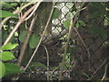
Clouded Leopard
Part of Howletts Animal Park.
Seen from a footpath from Bekesbourne Lane towards the A257 Canterbury Road.
See http://en.wikipedia.org/wiki/Clouded_Leopard for more details on the wildcat.
Image: © David Anstiss
Taken: 15 Aug 2010
0.09 miles
8
Footpath towards Bekesbourne
A path leads from the Lower Garrington Farm track past the wood near the watercress beds, then towards a railway before leading towards School Lane, Bekesbourne.
Image: © David Anstiss
Taken: 15 Aug 2010
0.11 miles
9
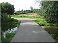
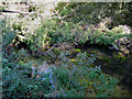
Bridge near the watercress beds
A farm track from Lower Garrington Farm towards Bekesbourne Lane.
It passes over a stream on watercress beds near the river Nail Bourne.
Image: © David Anstiss
Taken: 15 Aug 2010
0.15 miles