IMAGES TAKEN NEAR TO
Grove Road, CANTERBURY, CT3 1SB
Introduction
This page details the photographs taken nearby to Grove Road, CT3 1SB by members of the Geograph project.
The Geograph project started in 2005 with the aim of publishing, organising and preserving representative images for every square kilometre of Great Britain, Ireland and the Isle of Man.

There are currently over 7.5m images from over14,400 individuals and you can help contribute to the project by visiting https://www.geograph.org.uk
Image Map
Images are licensed for reuse under creativecommons.org/licenses/by-sa/2.0
Notes
- Clicking on the map will re-center to the selected point.
- The higher the marker number, the further away the image location is from the centre of the postcode.
Image Listing (8 Images Found)
Images are licensed for reuse under creativecommons.org/licenses/by-sa/2.0
Image
Details
Distance
1
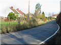
Frognall Cottages, Grove Road, Wickhambreaux.
Image: © Nick Smith
Taken: 21 Jan 2007
0.05 miles
3
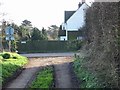
Junction of minor road with Grove Road at Frognall.
Image: © Nick Smith
Taken: 21 Jan 2007
0.14 miles
4
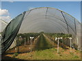
Strawberry Polytunnel
Part of Quaives Farm.
Seen from a footpath heading towards Hollybush Road.
Image: © David Anstiss
Taken: 11 Jul 2010
0.15 miles
5
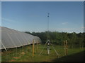
Weather Station in Quaives Farm
This weather station is between several large strawberry polytunnels.
As seen from a footpath from Hollybush Lane to Grove Road.
Image: © David Anstiss
Taken: 11 Jul 2010
0.15 miles
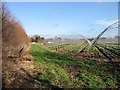
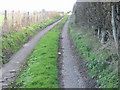
6
Track in Quaives Farm
This farm track leads to several fields of polytunnels of the farm.
It is also the route of a footpath from Grove Road to Hollybush Lane.
Image: © David Anstiss
Taken: 11 Jul 2010
0.18 miles
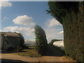
8
Off Grove Road
Clearing opposite Grove Road.
Image: © Wayland Smith
Taken: 2 May 2022
0.24 miles