IMAGES TAKEN NEAR TO
Cave Lane, CANTERBURY, CT3 1PA
Introduction
This page details the photographs taken nearby to Cave Lane, CT3 1PA by members of the Geograph project.
The Geograph project started in 2005 with the aim of publishing, organising and preserving representative images for every square kilometre of Great Britain, Ireland and the Isle of Man.

There are currently over 7.5m images from over14,400 individuals and you can help contribute to the project by visiting https://www.geograph.org.uk
Image Map
Images are licensed for reuse under creativecommons.org/licenses/by-sa/2.0
Notes
- Clicking on the map will re-center to the selected point.
- The higher the marker number, the further away the image location is from the centre of the postcode.
Image Listing (23 Images Found)
Images are licensed for reuse under creativecommons.org/licenses/by-sa/2.0
Image
Details
Distance
2
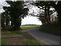
Cave Lane and Goodnestone Hill Lane junction
Crockshard Hill from Crockshard Farm divides here.
Cave Lane leads left towards Millers Farm near Chillenden.
Goodnestone Hill leads right towards Goodnestone.
A bridleway also crosses this junction from Loverswalk Wood (from the right), to Bushy Rough (heading left).
Image: © David Anstiss
Taken: 19 Dec 2010
0.10 miles
3
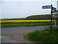
Goodnestone Road meets Cave Lane
Goodnestone Road is to the left while Cave Lane is to the right. The road behind, which actually leads to Goodnestone, does not have a name. The wood beyond the field of oilseed rape is Bushy Rough.
Image: © Marathon
Taken: 2 May 2015
0.12 miles
4
Bridleway to Crockshard Hill
A track leads from Love Lane, past The Serpentine (wood in Goodnestone Park) and then Loveswalk Wood leading to Crockshard Hill near Saddlers Hill road junction.
Image: © David Anstiss
Taken: 19 Dec 2010
0.13 miles
5
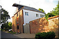
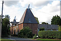
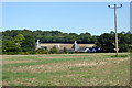
The Oast House, Cave Lane, Goodnestone, Canterbury, Kent
Image: © Oast House Archive
Taken: 15 Aug 2008
0.16 miles
6
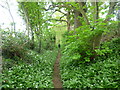
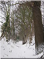
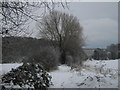
Path at the edge of Loverswalk Wood
This is at the northern end of Loverswalk Wood on the way to Cave Lane. Ramsons, also known as wild garlic, can be seen on either side of the path.
Image: © Marathon
Taken: 2 May 2015
0.16 miles
7
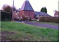
Oast houses at Claypots
There are four in all, one hidden by the trees to the left.
Image: © Robin Webster
Taken: 2 Sep 2017
0.17 miles
8
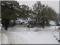
Bridleway to Bushy Rough
A bridleway leads down from Cave Lane towards the wood (in the background on the left) on Twitham Hill, before heading to Crixhall Court on Buckland Lane.
Image: © David Anstiss
Taken: 19 Dec 2010
0.17 miles