IMAGES TAKEN NEAR TO
Dene Farm Lane, CANTERBURY, CT3 1NU
Introduction
This page details the photographs taken nearby to Dene Farm Lane, CT3 1NU by members of the Geograph project.
The Geograph project started in 2005 with the aim of publishing, organising and preserving representative images for every square kilometre of Great Britain, Ireland and the Isle of Man.

There are currently over 7.5m images from over14,400 individuals and you can help contribute to the project by visiting https://www.geograph.org.uk
Image Map
Images are licensed for reuse under creativecommons.org/licenses/by-sa/2.0
Notes
- Clicking on the map will re-center to the selected point.
- The higher the marker number, the further away the image location is from the centre of the postcode.
Image Listing (12 Images Found)
Images are licensed for reuse under creativecommons.org/licenses/by-sa/2.0
Image
Details
Distance
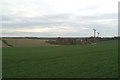
2
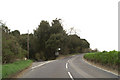
B2046 Adisham Road
This road leads from the A2 Dual Carriageway, past Aylesham and Adisham before heading towards Wingham.
Image: © David Anstiss
Taken: 19 Dec 2010
0.16 miles
3
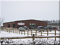
Gibsons Farm Shop
This large barn style building is on the junction of the B2046 Adisham Road and Crockshard Lane. It has a farmshop, florist, cafe and gallery.
See http://www.gibsonsfarmshop.com/ for more details.
Image: © David Anstiss
Taken: 19 Dec 2010
0.18 miles
4
Horse jumps near Little Crockshards Farm
Image: © Nick Smith
Taken: 23 Sep 2010
0.20 miles
6
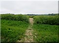
Bridleway to Wingham Well Lane
Public bridleway EE178. At this point although the path proceeds due north the OS explorer map indicates that the public bridleway continues north-northeast through the rape field.
Image: © Peter Holmes
Taken: 30 May 2016
0.22 miles
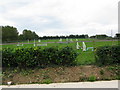
7
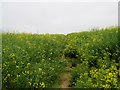
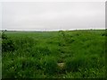
Path through field of rapeseed
Bridleway to Bossington Farm. According to OS Explorer map the actual route of the public bridleway EE178 is through the crops some way to the east of this path.
Image: © Peter Holmes
Taken: 30 May 2016
0.22 miles
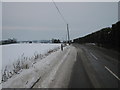
8
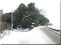
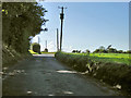
Road junction on the Adisham Road
The B2046 Adisham Road (has been cleared of snow) heads right towards Wingham.
Wingham Well Lane leads left and down an icy path towards Wingham Well.
Compare with Image in Summer.
Image: © David Anstiss
Taken: 19 Dec 2010
0.23 miles
9
Bridleway to Bossington Farm
Public bridleway EE178.
Image: © Peter Holmes
Taken: 30 May 2016
0.23 miles
10
Crockshard Lane
Passing Crockshard Farm to the left.
Image: © Robin Webster
Taken: 2 Sep 2017
0.23 miles