IMAGES TAKEN NEAR TO
Grove Road, CANTERBURY, CT3 1LW
Introduction
This page details the photographs taken nearby to Grove Road, CT3 1LW by members of the Geograph project.
The Geograph project started in 2005 with the aim of publishing, organising and preserving representative images for every square kilometre of Great Britain, Ireland and the Isle of Man.

There are currently over 7.5m images from over14,400 individuals and you can help contribute to the project by visiting https://www.geograph.org.uk
Image Map
Images are licensed for reuse under creativecommons.org/licenses/by-sa/2.0
Notes
- Clicking on the map will re-center to the selected point.
- The higher the marker number, the further away the image location is from the centre of the postcode.
Image Listing (27 Images Found)
Images are licensed for reuse under creativecommons.org/licenses/by-sa/2.0
Image
Details
Distance
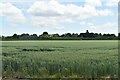
4
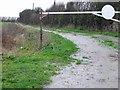
Footpath near The Groves
This track leads from Grove Road (past three houses, on the right) towards Brook Farm.
Image: © David Anstiss
Taken: 29 Nov 2010
0.04 miles
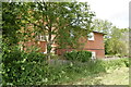
6
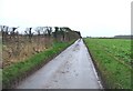
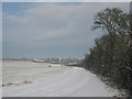
Looking SSW along Grove Road, near Staple.
Image: © Nick Smith
Taken: 10 Jan 2007
0.08 miles
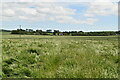
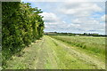
9
Farm track to Great Pedding Farm
This track leads from the track from Grove Road to Brook Farm.
Great Pedding Farm is in the background.
Image: © David Anstiss
Taken: 29 Nov 2010
0.14 miles
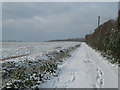
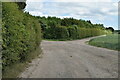
10
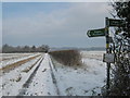
Footpath junction near Staple
A footpath leads along Grove Road towards The Groves (three houses in a field), and onwards to Great Pedding Farm. Another footpath heads left diagonally across a field towards a farm track heading to Brook Farm. Another path heads right (diagonally across a field) to The Rookery (houses on Durlock Road).
Lastly a path heads right along the hedge towards School Lane in Staple.
Image: © David Anstiss
Taken: 29 Nov 2010
0.15 miles