IMAGES TAKEN NEAR TO
Buckland Lane, CANTERBURY, CT3 1JY
Introduction
This page details the photographs taken nearby to Buckland Lane, CT3 1JY by members of the Geograph project.
The Geograph project started in 2005 with the aim of publishing, organising and preserving representative images for every square kilometre of Great Britain, Ireland and the Isle of Man.

There are currently over 7.5m images from over14,400 individuals and you can help contribute to the project by visiting https://www.geograph.org.uk
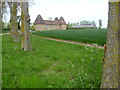
Image Map
Images are licensed for reuse under creativecommons.org/licenses/by-sa/2.0
Notes
- Clicking on the map will re-center to the selected point.
- The higher the marker number, the further away the image location is from the centre of the postcode.
Image Listing (22 Images Found)
Images are licensed for reuse under creativecommons.org/licenses/by-sa/2.0
Image
Details
Distance
1
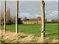
Crixhall Court
Crixhall Court dates from the 16th century and early 17th century. It is Grade II* Listed. For a detailed description see http://www.britishlistedbuildings.co.uk/en-178252-crixhall-court-staple-kent#.VUZtjvlViko For details of it as an oast house see http://www.geograph.org.uk/photo/928226
Image: © Marathon
Taken: 2 May 2015
0.04 miles
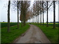
2
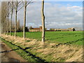
Crixhall Court.
Avenue of trees leading to Crixhall Court.
Image: © Nick Smith
Taken: 4 Jan 2007
0.05 miles
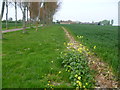
3
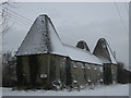
Crixhall Court Oast House
Close to an access road to the court and farm from Buckland Lane.
Image: © David Anstiss
Taken: 19 Dec 2010
0.06 miles
4
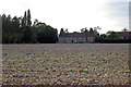
Oast House at Crixhall Court, Buckland Lane, Staple, Kent
Image: © Oast House Archive
Taken: 15 Aug 2008
0.07 miles
6
Crixhall Court from Buckland Lane
Crixhall Court dates from the 16th century and early 17th century. It is Grade II* Listed. A close up can be seen at http://www.geograph.org.uk/photo/4458316 The avenue of trees on the left follows the driveway to Crixhall Court from Buckland Lane.
For a detailed description see http://www.britishlistedbuildings.co.uk/en-178252-crixhall-court-staple-kent#.VUZtjvlViko For details of it as an oast house see http://www.geograph.org.uk/photo/928226
Image: © Marathon
Taken: 2 May 2015
0.12 miles
7
Avenue of Trees
This avenue of trees follows the driveway of Crixhall Court to reach Buckland Lane a little way ahead at the end of the avenue.
Image: © Marathon
Taken: 2 May 2015
0.15 miles
8
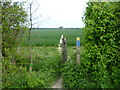
Footpath to Staple
The footpath from Claypits runs in almost a straight line to Staple. Here it crosses the footpath from Twitham Hill to Crixhall Court.
Image: © Marathon
Taken: 2 May 2015
0.16 miles
9
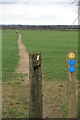
Claypits footpath EE190 towards Staple
Claypits to Staple path EE190 at the junction with bridleway EE28. The path continues across arable fields towards Church Lane and Staple.
Image: © Hugh Craddock
Taken: 21 Feb 2017
0.16 miles
10
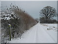
Footpath junction on the bridleway near Crixhall Court
A bridleway (track) leads from Cave Lane towards the farm near Buckland Lane.
A footpath leads left to The Street, Staple or right to Cave Lane near Goodnestone.
Image: © David Anstiss
Taken: 19 Dec 2010
0.17 miles