IMAGES TAKEN NEAR TO
Stourmouth, CANTERBURY, CT3 1HT
Introduction
This page details the photographs taken nearby to CT3 1HT by members of the Geograph project.
The Geograph project started in 2005 with the aim of publishing, organising and preserving representative images for every square kilometre of Great Britain, Ireland and the Isle of Man.

There are currently over 7.5m images from over14,400 individuals and you can help contribute to the project by visiting https://www.geograph.org.uk
Image Map
Images are licensed for reuse under creativecommons.org/licenses/by-sa/2.0
Notes
- Clicking on the map will re-center to the selected point.
- The higher the marker number, the further away the image location is from the centre of the postcode.
Image Listing (55 Images Found)
Images are licensed for reuse under creativecommons.org/licenses/by-sa/2.0
Image
Details
Distance
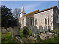
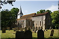
4
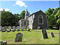
Stourmouth church
All Saints is a grade I listed building, main fabric Saxon.
Image: © Robin Webster
Taken: 15 Jun 2019
0.04 miles
5
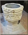
West Stourmouth - Font
Inside the redundant All Saints Church which has Saxon roots.
Image: © Colin Smith
Taken: 8 Jan 2018
0.04 miles
6
Snowdrops in the churchyard at All Saints Church West Stourmouth
Image: © pam fray
Taken: 3 Mar 2009
0.04 miles
7
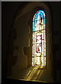
Window in the church of All Saints, West Stourmouth
Image: © pam fray
Taken: 22 Mar 2012
0.04 miles
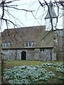
9
All Saints Church, West Stourmouth
No longer in use for services, but a Grade I listed building with Saxon origins.
Image: © Bill Boaden
Taken: 28 Jun 2012
0.04 miles
10
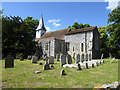
Stourmouth church
All Saints is a grade I listed building, main fabric Saxon.
Image: © Robin Webster
Taken: 15 Jun 2019
0.04 miles