IMAGES TAKEN NEAR TO
Popsall Lane, CANTERBURY, CT3 1AT
Introduction
This page details the photographs taken nearby to Popsall Lane, CT3 1AT by members of the Geograph project.
The Geograph project started in 2005 with the aim of publishing, organising and preserving representative images for every square kilometre of Great Britain, Ireland and the Isle of Man.

There are currently over 7.5m images from over14,400 individuals and you can help contribute to the project by visiting https://www.geograph.org.uk
Image Map
Images are licensed for reuse under creativecommons.org/licenses/by-sa/2.0
Notes
- Clicking on the map will re-center to the selected point.
- The higher the marker number, the further away the image location is from the centre of the postcode.
Image Listing (51 Images Found)
Images are licensed for reuse under creativecommons.org/licenses/by-sa/2.0
Image
Details
Distance
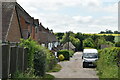
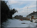
2
Home Meadow, Popsal Lane
Planning permission was granted by Dover District Council under application number DOV/15/00977 for the “erection of a two storey side extension, part two storey and single storey rear extension, two dormers and rooflights”.
The work was ongoing when this view was taken.
Image: © John Baker
Taken: 15 Dec 2019
0.03 miles
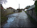
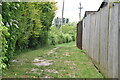
5
Byway to Dam Bridge
This track leads from Popsal Lane.
Image: © David Anstiss
Taken: 29 Nov 2010
0.07 miles
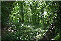
7
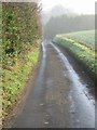
Popsal Lane on a misty morning
Looking E along Popsal Lane
Image: © Nick Smith
Taken: 23 Dec 2007
0.08 miles
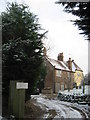
8
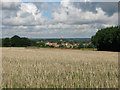
View from trig point on Blackney Hill
The village and church in the distance is Wingham.
Image: © Nick Smith
Taken: 3 Sep 2010
0.09 miles
10
View of Wingham
Taken from a byway running between Popsal Lane and Staple Road, it shows houses along Staple Road, the spire of St Mary’s church and industrial buildings along Goodnestone Road.
Image: © John Baker
Taken: 15 Dec 2019
0.10 miles