IMAGES TAKEN NEAR TO
Jasmine Place, High Street, CANTERBURY, CT3 1AD
Introduction
This page details the photographs taken nearby to Jasmine Place, High Street, CT3 1AD by members of the Geograph project.
The Geograph project started in 2005 with the aim of publishing, organising and preserving representative images for every square kilometre of Great Britain, Ireland and the Isle of Man.

There are currently over 7.5m images from over14,400 individuals and you can help contribute to the project by visiting https://www.geograph.org.uk
Image Map
Images are licensed for reuse under creativecommons.org/licenses/by-sa/2.0
Notes
- Clicking on the map will re-center to the selected point.
- The higher the marker number, the further away the image location is from the centre of the postcode.
Image Listing (199 Images Found)
Images are licensed for reuse under creativecommons.org/licenses/by-sa/2.0
Image
Details
Distance
1
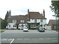
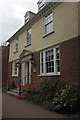
Row of Cottages
Grade II listed. http://www.britishlistedbuildings.co.uk/en-178328-56-and-60-61-high-street-wingham-kent . See Image for a close up of the left hand cottage.
Image: © N Chadwick
Taken: 12 Jan 2013
0.02 miles
3
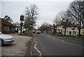
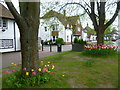
High Street, Wingham
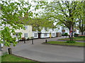
Wingham became established as a village in Roman times. It is an attractive village on the main Canterbury to Sandwich Road. This is a service road which runs parallel to the High Street. For more about Wingham see http://en.wikipedia.org/wiki/Wingham,_Kent
Image: © Marathon
Taken: 2 May 2015
0.03 miles
4
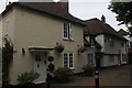
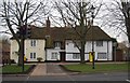
61 The old Watchmakers cottage, 60 and 56 High Street, Wingham
Grade II Listed 15th century Hall house with cross wing plan extended in the 18th century and now converted to 3 houses.
Image: © Jo and Steve Turner
Taken: 8 Jul 2016
0.03 miles
5
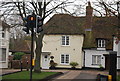
The Old Watchmakers Cottage
Grade II listed. http://www.britishlistedbuildings.co.uk/en-178328-56-and-60-61-high-street-wingham-kent . See Image for a wider photo of the cottages.
Image: © N Chadwick
Taken: 12 Jan 2013
0.03 miles
6
67, High St
Grade II listed. http://www.britishlistedbuildings.co.uk/en-178329-67-high-street-wingham-kent
Image: © N Chadwick
Taken: 12 Jan 2013
0.03 miles
7
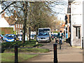
High Street, Wingham
Wingham became established as a village in Roman times. It is an attractive village on the main Canterbury to Sandwich Road. This is a service road which runs parallel to the High Street. The road ahead branching off is St Mary's Meadow.
For more information about Wingham see http://en.wikipedia.org/wiki/Wingham,_Kent
Image: © Marathon
Taken: 2 May 2015
0.03 miles
8
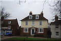
Street Farm House, 67 High Street, Wingham
Early 18th century Grade II Listed house altered early in the 19th century.
Image: © Jo and Steve Turner
Taken: 8 Jul 2016
0.04 miles