IMAGES TAKEN NEAR TO
Chapel Lane, CANTERBURY, CT2 9HA
Introduction
This page details the photographs taken nearby to Chapel Lane, CT2 9HA by members of the Geograph project.
The Geograph project started in 2005 with the aim of publishing, organising and preserving representative images for every square kilometre of Great Britain, Ireland and the Isle of Man.

There are currently over 7.5m images from over14,400 individuals and you can help contribute to the project by visiting https://www.geograph.org.uk
Image Map
Images are licensed for reuse under creativecommons.org/licenses/by-sa/2.0
Notes
- Clicking on the map will re-center to the selected point.
- The higher the marker number, the further away the image location is from the centre of the postcode.
Image Listing (29 Images Found)
Images are licensed for reuse under creativecommons.org/licenses/by-sa/2.0
Image
Details
Distance
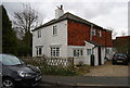
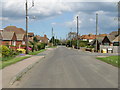
1
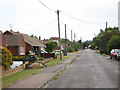
Chapel Lane
A dead end road off the A290 Blean Common. The lane leads of Walnut Tree Farm and a footpath continues into Clowes Wood.
Image: © Oast House Archive
Taken: 31 May 2011
0.01 miles
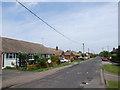
5
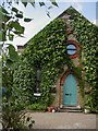
The old chapel at Blean
Converted to a dwelling by 2002.
Image: © Rog Frost
Taken: 25 May 2002
0.03 miles
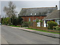
6
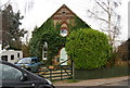
Chapel House, Chapel Lane, Blean
An old chapel now converted to a private residence.
Image: © N Chadwick
Taken: 14 Mar 2009
0.04 miles
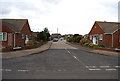
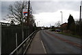
7
View along the A290, Blean Common Road
Entrance to Chapel Lane is just to the right of the temporary traffic lights.
Image: © Nick Smith
Taken: 8 Apr 2008
0.05 miles
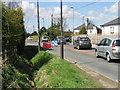
10
Bus Stop, Blean Common (A290)
The Whitstable to Canterbury bus stops here
Image: © N Chadwick
Taken: 14 Mar 2009
0.07 miles