IMAGES TAKEN NEAR TO
Rough Common Road, CANTERBURY, CT2 9BW
Introduction
This page details the photographs taken nearby to Rough Common Road, CT2 9BW by members of the Geograph project.
The Geograph project started in 2005 with the aim of publishing, organising and preserving representative images for every square kilometre of Great Britain, Ireland and the Isle of Man.

There are currently over 7.5m images from over14,400 individuals and you can help contribute to the project by visiting https://www.geograph.org.uk
Image Map
Images are licensed for reuse under creativecommons.org/licenses/by-sa/2.0
Notes
- Clicking on the map will re-center to the selected point.
- The higher the marker number, the further away the image location is from the centre of the postcode.
Image Listing (17 Images Found)
Images are licensed for reuse under creativecommons.org/licenses/by-sa/2.0
Image
Details
Distance
1
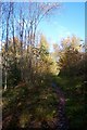
Footpath in Stock Wood
This path leads from Wingate Hill towards Rough Common Road.
Image: © David Anstiss
Taken: 15 Nov 2009
0.11 miles
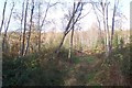
2
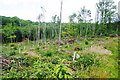
Hillside in Stock Wood
A sector where there has been harvesting and replanting.
Image: © Bill Boaden
Taken: 25 Jun 2012
0.14 miles
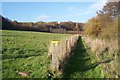
4
Footpath from Harbledown to Rough Common
It follows the valley bottom for a while before striking right up the valley side.
Image: © Bill Boaden
Taken: 25 Jun 2012
0.17 miles
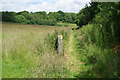
5
Footpath towards Rough Common
This path leads from Wingate Hill towards Stock Wood.
Image: © David Anstiss
Taken: 15 Nov 2009
0.18 miles
6
Track to coppice area in Stock Wood
This track leads off the footpath to Rough Common Road.
Image: © David Anstiss
Taken: 15 Nov 2009
0.19 miles
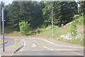
7
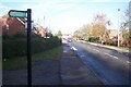
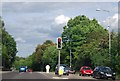
Rough Common Road
This road leads from Palmers Cross Hill to the A290 Whitstable Road. The footpath on the left leads through Stock Wood to Wingate Hill.
Image: © David Anstiss
Taken: 15 Nov 2009
0.21 miles
9
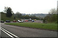
Queuing to get onto the A2050 at Harbledown
The A2050 replaced the section of the old A2 which ran through Canterbury. The new A2 by-passes the city altogether, to the West of here.
Image: © David Long
Taken: 21 Apr 2006
0.23 miles