IMAGES TAKEN NEAR TO
Church Hill, CANTERBURY, CT2 9AQ
Introduction
This page details the photographs taken nearby to Church Hill, CT2 9AQ by members of the Geograph project.
The Geograph project started in 2005 with the aim of publishing, organising and preserving representative images for every square kilometre of Great Britain, Ireland and the Isle of Man.

There are currently over 7.5m images from over14,400 individuals and you can help contribute to the project by visiting https://www.geograph.org.uk
Image Map
Images are licensed for reuse under creativecommons.org/licenses/by-sa/2.0
Notes
- Clicking on the map will re-center to the selected point.
- The higher the marker number, the further away the image location is from the centre of the postcode.
Image Listing (27 Images Found)
Images are licensed for reuse under creativecommons.org/licenses/by-sa/2.0
Image
Details
Distance
1
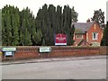
Kent College
Infants and Junior School at Kent College, Harbledown, just off the A2050 near Canterbury.
Image: © Roger May
Taken: 12 Sep 2005
0.01 miles
2
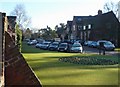
Part of Kent College, Vernon Holme, near Harbledown
Image: © pam fray
Taken: 10 Dec 2008
0.01 miles
3
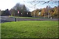
Faulkners Lane meets the A2050
Faulkners Lane ( on the left heads behind the viewer to Church Hill towards Harbledown, from Chatham Hatch. The A2050 (on the right) heads behind the viewer towards Canterbury City Centre, from the A2 Dual Carriageway.
Image: © David Anstiss
Taken: 15 Nov 2009
0.04 miles
4
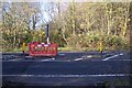
Footpath crosses the A2050
A path from Faulkners Lane, near Kent College, Vernon Holme crosses the busy access road towards Canterbury (heading right) from the A2 Dual carriageway.
Image: © David Anstiss
Taken: 15 Nov 2009
0.09 miles
5
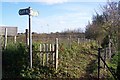
Canterbury Centenary Walk on Church Hill
Kent County Council had several walks signposted around various cities in Kent for the celebration of a hundred years of the Council. Maidstone did have one but (due to funding) most of the signs have been removed !!. This section of the path heads towards the North Downs Way (long distance path)
See http://www.bertuchi.co.uk/canterbury.php for more of the walk.
Image: © David Anstiss
Taken: 15 Nov 2009
0.09 miles
6
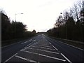
A2050, Harbledown
This is the main route out of Canterbury leading to London and the A2.
Image: © Chris Whippet
Taken: 24 Nov 2013
0.13 miles
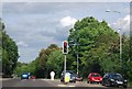
8
Queuing to get onto the A2050 at Harbledown
The A2050 replaced the section of the old A2 which ran through Canterbury. The new A2 by-passes the city altogether, to the West of here.
Image: © David Long
Taken: 21 Apr 2006
0.14 miles
9
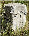
Old Milestone by Church Hill, Harbledown
Carved stone post by the UC road, in parish of Harbledown (Canterbury District), Church Hill, West of Harbledown, on the verge, on North side of road. Dover Road facet, erected by the Chatham & Canterbury turnpike trust in the 19th century.
Inscription reads:-
: 1744 : : CANTERBURY / 1 : : LONDON / 54 :
Rivet benchmark on top.
Kent HER.
HER Number: TR 15 NW 1521 https://www.heritagegateway.org.uk/Gateway/Results_Single.aspx?uid=MKE77996&resourceID=1005
Milestone Society National ID: KE_LD54
Image: © Simon Westerman
Taken: 6 Aug 2024
0.14 miles
10
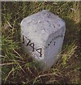
Old Milestone by Church Hill, Harbledown
Carved stone post by the UC road, in parish of Harbledown (Canterbury District), Church Hill, West of Harbledown, on the verge, on North side of road. Dover Road facet, erected by the Chatham & Canterbury turnpike trust in the 19th century.
Inscription reads:-
: 1744 : : CANTERBURY / 1 : : LONDON / 54 :
Rivet benchmark on top.
Kent HER.
HER Number: TR 15 NW 1521 https://www.heritagegateway.org.uk/Gateway/Results_Single.aspx?uid=MKE77996&resourceID=1005
Milestone Society National ID: KE_LD54
Image: © C Woodward
Taken: 2 Jul 2007
0.14 miles