IMAGES TAKEN NEAR TO
Wingate Hill, CANTERBURY, CT2 9AJ
Introduction
This page details the photographs taken nearby to Wingate Hill, CT2 9AJ by members of the Geograph project.
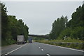
The Geograph project started in 2005 with the aim of publishing, organising and preserving representative images for every square kilometre of Great Britain, Ireland and the Isle of Man.

There are currently over 7.5m images from over14,400 individuals and you can help contribute to the project by visiting https://www.geograph.org.uk
Image Map
Images are licensed for reuse under creativecommons.org/licenses/by-sa/2.0
Notes
- Clicking on the map will re-center to the selected point.
- The higher the marker number, the further away the image location is from the centre of the postcode.
Image Listing (18 Images Found)
Images are licensed for reuse under creativecommons.org/licenses/by-sa/2.0
Image
Details
Distance
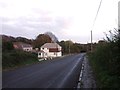
2
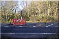
Road junction on the A2050
Wingate Hill heads right towards Upper Harbledown. The A2050 heads straight on towards the A2 Dual Carriageway, from Canterbury.
Image: © David Anstiss
Taken: 15 Nov 2009
0.05 miles
3
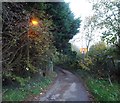
Wingate Hill, Harbledown
The old road was by-passed by a dual carriageway in the 1970s, this lane now leads to a handful of properties.
Image: © Chris Whippet
Taken: 24 Nov 2013
0.07 miles
4
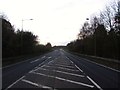
A2050, Harbledown
This is the main route out of Canterbury leading to London and the A2.
Image: © Chris Whippet
Taken: 24 Nov 2013
0.08 miles
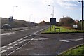
5
Footpath crosses the A2050
A path from Faulkners Lane, near Kent College, Vernon Holme crosses the busy access road towards Canterbury (heading right) from the A2 Dual carriageway.
Image: © David Anstiss
Taken: 15 Nov 2009
0.14 miles
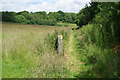
6
Footpath towards Rough Common
This path leads from Wingate Hill towards Stock Wood.
Image: © David Anstiss
Taken: 15 Nov 2009
0.14 miles
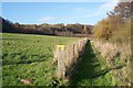
7
Footpath from Harbledown to Rough Common
It follows the valley bottom for a while before striking right up the valley side.
Image: © Bill Boaden
Taken: 25 Jun 2012
0.17 miles
8
North Downs Way on a bridleway to Harbledown
The path heads down a bridleway close to the A2 Dual Carriageway (on the right). From Faulkners Lane towards Golden Hill, Harbledown.
Image: © David Anstiss
Taken: 15 Nov 2009
0.17 miles
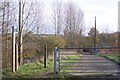
10
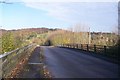
Faulkners Lane bridge over the A2 Dual Carriageway
The lane leads from Chartham Hatch towards Harbledown. Blean Wood is in the background on the left. The bridge is also used by the North Downs Way heading to Harbledown.
Image: © David Anstiss
Taken: 15 Nov 2009
0.20 miles