IMAGES TAKEN NEAR TO
Whitehall Road, CANTERBURY, CT2 8NL
Introduction
This page details the photographs taken nearby to Whitehall Road, CT2 8NL by members of the Geograph project.
The Geograph project started in 2005 with the aim of publishing, organising and preserving representative images for every square kilometre of Great Britain, Ireland and the Isle of Man.

There are currently over 7.5m images from over14,400 individuals and you can help contribute to the project by visiting https://www.geograph.org.uk
Image Map
Images are licensed for reuse under creativecommons.org/licenses/by-sa/2.0
Notes
- Clicking on the map will re-center to the selected point.
- The higher the marker number, the further away the image location is from the centre of the postcode.
Image Listing (82 Images Found)
Images are licensed for reuse under creativecommons.org/licenses/by-sa/2.0
Image
Details
Distance
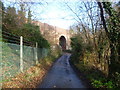
1

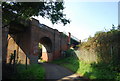
Whitehall Road alongside the railway line
Whitehall Road is followed here by the Stour Valley Walk. The railway line on the left is between Chartham and Canterbury West which here follows Whitehall Road.
The South Eastern Railway began its services from Ashford to what is now Canterbury West on 6th February 1846 and the line was extended to Ramsgate two months later.
Image: © Marathon
Taken: 14 Dec 2013
0.03 miles
2
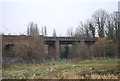
Railway bridge over a small lane to Harbledown
The bridge on the right hand side is the Main London to Dover line crossing the Ashford to Ramsgate line below.
Image: © N Chadwick
Taken: 27 Sep 2008
0.04 miles
5
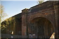
Railway Bridge over Whitehall Road
Notice under the bridge states "ELR-FDM Structure 260. Orchard/Whitehall Road between Selling Station and Canterbury East Station."
I thought I was following the Great Stour Walk under this bridge, only to find it has been moved to the riverbank.
Image: © Chris Heaton
Taken: 9 Aug 2015
0.07 miles
6
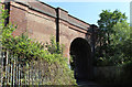
Railway bridge over Whitehall Road
This view is from the Stour Valley Walk which here follows Whitehall Road. The railway bridge ahead carries the line between Faversham and Canterbury East which was opened on 9th July 1860 by the London, Chatham & Dover Railway.
On the left is the line between Chartham and Canterbury West which also passes under the Canterbury East line - see http://www.geograph.org.uk/photo/3779874
Image: © Marathon
Taken: 14 Dec 2013
0.07 miles
7
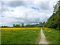
Buttercups at Hambrook Marshes, Canterbury
This is a reserve with public footpaths owned by the Kent Enterprise Trust, part of the Social Enterprise Kent Partnership. It was purchased in 2004 and is part of a designated Local Wildlife Site.
Image: © pam fray
Taken: 3 Jun 2015
0.07 miles
8
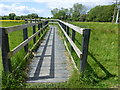
Boardwalk on Hambrook Marshes, Canterbury
This is owned by Kent Enterprise Trust. part of the Social Enterprise Kent Partnership. It was purchased in 2004 and is part of a designated Local Wildlife Site.
Image: © pam fray
Taken: 3 Jun 2015
0.07 miles
9

Graffiti under the railway bridge, Canterbury
Unusually painted with silver, this is by the Great Stour Way, a 3 mile path between Canterbury and Chartham for cyclists, pedestrians and the diabled.
Image: © pam fray
Taken: 3 Jun 2015
0.08 miles
10
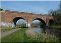
Railway bridge Canterbury
The bridge carries trains between Canterbury East and Faversham stations. The Great Stour river and cycle path run under it.
Image: © pam fray
Taken: 25 Mar 2011
0.08 miles