IMAGES TAKEN NEAR TO
Neals Place Road, CANTERBURY, CT2 8HX
Introduction
This page details the photographs taken nearby to Neals Place Road, CT2 8HX by members of the Geograph project.
The Geograph project started in 2005 with the aim of publishing, organising and preserving representative images for every square kilometre of Great Britain, Ireland and the Isle of Man.

There are currently over 7.5m images from over14,400 individuals and you can help contribute to the project by visiting https://www.geograph.org.uk
Image Map
Images are licensed for reuse under creativecommons.org/licenses/by-sa/2.0
Notes
- Clicking on the map will re-center to the selected point.
- The higher the marker number, the further away the image location is from the centre of the postcode.
Image Listing (27 Images Found)
Images are licensed for reuse under creativecommons.org/licenses/by-sa/2.0
Image
Details
Distance
1
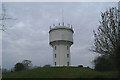
Chateau d'eaux fortifie
The mass of aerials sited on the water tower make it look more like a castle than ever
Image: © David Long
Taken: 21 Apr 2006
0.03 miles
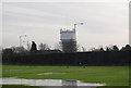
2
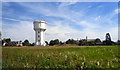
Water Tower and School
This undeveloped bit of set aside land gives a panorama of the water tower and the Hogwartesque (architectural term) towers and turrets of St Edmund's School.
Image: © Des Blenkinsopp
Taken: 20 Aug 2011
0.04 miles
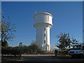
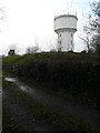
5

St. Thomas Hill Water Tower, Canterbury
Image: © Chris Whippet
Taken: 5 May 2014
0.08 miles
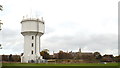
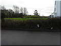
7
Old Kent Reservoir, St Thomas Hill
Seen from a track off St Thomas Hill, the reservoir is the irregular mound, with a water tower (known as St Thomas Tower) behind it. Planning permission has been granted by Canterbury City Council under application number CA//15/01298 for the “conversion of existing redundant water storage tank to form one four-bedroom dwelling with associated external works”.
Image: © John Baker
Taken: 4 Jan 2016
0.09 miles
8
Old Kent Reservoir, St Thomas Hill
Seen from Neal’s Place Road, the reservoir is the large mound to the right of the water tower. Planning permission has been granted by Canterbury City Council under application number CA//15/01298 for the “conversion of existing redundant water storage tank to form one four-bedroom dwelling with associated external works”.
Image: © John Baker
Taken: 4 Jan 2016
0.09 miles
9
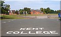
Kent College
Like it says on the road......
Founded in 1885, there is a bit about this school on http://en.wikipedia.org/wiki/Kent_College
Image: © Des Blenkinsopp
Taken: 20 Aug 2011
0.10 miles
10
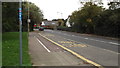
Whitstable Road, Canterbury
The blue marker on the post in the foreground indicates the route of National Cycle Network route 1, to John o'Groats. Cyclists use the pavement here rather than the road.
Image: © Malc McDonald
Taken: 26 Oct 2013
0.12 miles