IMAGES TAKEN NEAR TO
Queens View, CANTERBURY, CT2 8FG
Introduction
This page details the photographs taken nearby to Queens View, CT2 8FG by members of the Geograph project.
The Geograph project started in 2005 with the aim of publishing, organising and preserving representative images for every square kilometre of Great Britain, Ireland and the Isle of Man.

There are currently over 7.5m images from over14,400 individuals and you can help contribute to the project by visiting https://www.geograph.org.uk
Image Map
Images are licensed for reuse under creativecommons.org/licenses/by-sa/2.0
Notes
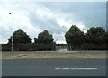
- Clicking on the map will re-center to the selected point.
- The higher the marker number, the further away the image location is from the centre of the postcode.
Image Listing (610 Images Found)
Images are licensed for reuse under creativecommons.org/licenses/by-sa/2.0
Image
Details
Distance
1
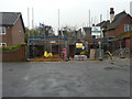
House under construction, Whitehall Bridge Road
Planning permission was granted by Canterbury City Council under application number CA//16/02903 for a “proposed detached two-storey dwelling with parking and integral garage”. The site was previously a parking space for 3, Queens Avenue, which is the house on the right.
Image: © John Baker
Taken: 29 Apr 2018
0.02 miles
2
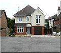
Recently completed house, Whitehall Bridge Road
This was the Image
Image: © John Baker
Taken: 4 Aug 2019
0.02 miles
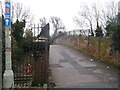
4
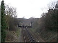
Railway to Chartham
As seen from Image
The railway line also passes under the A2050 Rhiems Way (heading right towards the A2 dual carriageway).
Image: © David Anstiss
Taken: 17 Feb 2014
0.03 miles
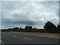
7
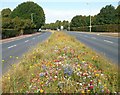
Flowery Road
Someone's put a colourful flower seed mix down the centre of the road here.
Image: © Des Blenkinsopp
Taken: 21 Aug 2011
0.04 miles
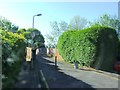
8
Whitehall Bridge, Canterbury
Railway bridge over the section of line between Canterbury West and Chartham.
The bridge is also used by National Cycle Route 1 (leading to Fordwich through Canterbury).
Image: © David Anstiss
Taken: 17 Feb 2014
0.05 miles
9
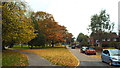
Autumn colours in Canterbury
In this image, taken in late October, leaves on the trees are turning gold and brown. Many have already fallen to the ground.
Image: © Malc McDonald
Taken: 26 Oct 2013
0.06 miles
10
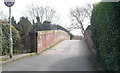
Whitehall Bridge, Canterbury
Railway bridge over the section of line between Canterbury West and Chartham.
Image: © pam fray
Taken: 29 Mar 2009
0.06 miles