IMAGES TAKEN NEAR TO
Hillside Avenue, CANTERBURY, CT2 8ET
Introduction
This page details the photographs taken nearby to Hillside Avenue, CT2 8ET by members of the Geograph project.
The Geograph project started in 2005 with the aim of publishing, organising and preserving representative images for every square kilometre of Great Britain, Ireland and the Isle of Man.

There are currently over 7.5m images from over14,400 individuals and you can help contribute to the project by visiting https://www.geograph.org.uk
Image Map
Images are licensed for reuse under creativecommons.org/licenses/by-sa/2.0
Notes
- Clicking on the map will re-center to the selected point.
- The higher the marker number, the further away the image location is from the centre of the postcode.
Image Listing (17 Images Found)
Images are licensed for reuse under creativecommons.org/licenses/by-sa/2.0
Image
Details
Distance
1
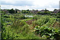
Allotments above St Dunstan's
The allotments are on the north western edge of Canterbury.
Image: © Bill Boaden
Taken: 25 Jun 2012
0.04 miles
2
Meadow Road
Looking East over Canterbury from Neal's Place.
Image: © Ben Charlton
Taken: 6 May 2004
0.07 miles
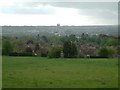
4
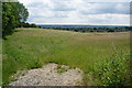
Open grassy field above Canterbury
The field is on the northern side of the Stour valley, and the view here is over the western edge of Canterbury.
Image: © Bill Boaden
Taken: 25 Jun 2012
0.15 miles
8
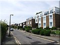
St John Stone House, 41 St Thomas Hill
Planning permission has been granted by Canterbury City Council under application number CA//15/01389 for the “demolition of the existing fire-damaged building and the erection of a new building, comprising student accommodation, chaplaincy accommodation, lounge and chapel”.
Image: © John Baker
Taken: 27 Dec 2015
0.20 miles
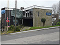
9

The remains of St John Stone House, 41, St Thomas Hill
Planning permission was granted by Canterbury City Council under application number CA//15/01389 for the “demolition of the existing fire damaged building and the erection of a new building, comprising student accommodation, chaplaincy accommodation, lounge and chapel”. Almost all the building has been demolished, other than a small section of wall between the electricity pole and shipping container. This is Image before it was demolished.
Image: © John Baker
Taken: 19 Feb 2017
0.20 miles