IMAGES TAKEN NEAR TO
Cherry Garden Road, CANTERBURY, CT2 8EL
Introduction
This page details the photographs taken nearby to Cherry Garden Road, CT2 8EL by members of the Geograph project.
The Geograph project started in 2005 with the aim of publishing, organising and preserving representative images for every square kilometre of Great Britain, Ireland and the Isle of Man.

There are currently over 7.5m images from over14,400 individuals and you can help contribute to the project by visiting https://www.geograph.org.uk
Image Map
Images are licensed for reuse under creativecommons.org/licenses/by-sa/2.0
Notes
- Clicking on the map will re-center to the selected point.
- The higher the marker number, the further away the image location is from the centre of the postcode.
Image Listing (26 Images Found)
Images are licensed for reuse under creativecommons.org/licenses/by-sa/2.0
Image
Details
Distance
3
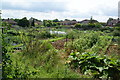
Allotments above St Dunstan's
The allotments are on the north western edge of Canterbury.
Image: © Bill Boaden
Taken: 25 Jun 2012
0.13 miles
6
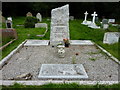
The Joseph Conrad grave, Canterbury Cemetery
The cemetery is in Westgate Court Avenue. The main stone is in memory of Joseph Teador Conrad Korzeniowski, 1857 - 1924. the famous Polish author of books such as "Lord Jim" and "Heart of Darkness", and his wife, Jessie Emmilene. They lived in Bishopsbourne, where he died in "Oswalds". Other members of his family are represented, including his two sons, John Alexander and (Alfred) Borys.
Image: © pam fray
Taken: 7 Aug 2012
0.16 miles
8

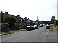
Junction of Harkness Drive with the A290 Whitstable Road
Image: © Nick Smith
Taken: 8 Apr 2008
0.17 miles
9

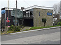
The remains of St John Stone House, 41, St Thomas Hill
Planning permission was granted by Canterbury City Council under application number CA//15/01389 for the “demolition of the existing fire damaged building and the erection of a new building, comprising student accommodation, chaplaincy accommodation, lounge and chapel”. Almost all the building has been demolished, other than a small section of wall between the electricity pole and shipping container. This is Image before it was demolished.
Image: © John Baker
Taken: 19 Feb 2017
0.17 miles
10
St John Stone House, 41 St Thomas Hill
Planning permission has been granted by Canterbury City Council under application number CA//15/01389 for the “demolition of the existing fire-damaged building and the erection of a new building, comprising student accommodation, chaplaincy accommodation, lounge and chapel”.
Image: © John Baker
Taken: 27 Dec 2015
0.17 miles