IMAGES TAKEN NEAR TO
Whitehall Gardens, CANTERBURY, CT2 8BD
Introduction
This page details the photographs taken nearby to Whitehall Gardens, CT2 8BD by members of the Geograph project.
The Geograph project started in 2005 with the aim of publishing, organising and preserving representative images for every square kilometre of Great Britain, Ireland and the Isle of Man.

There are currently over 7.5m images from over14,400 individuals and you can help contribute to the project by visiting https://www.geograph.org.uk
Image Map
Images are licensed for reuse under creativecommons.org/licenses/by-sa/2.0
Notes
- Clicking on the map will re-center to the selected point.
- The higher the marker number, the further away the image location is from the centre of the postcode.
Image Listing (1027 Images Found)
Images are licensed for reuse under creativecommons.org/licenses/by-sa/2.0
Image
Details
Distance
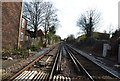
1
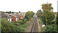
Railway tracks, Canterbury
Railway tracks approaching Canterbury West station, one of two railway stations which serve the city of Canterbury. In the middle distance, a car is crossing the railway on a level crossing.
The railway is electrified using the third rail system.
Image: © Malc McDonald
Taken: 26 Oct 2013
0.03 miles
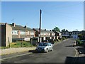
2
Hold up on the A290
Canterbury West Station is to the right of the level crossing
Image: © David Long
Taken: 21 Apr 2006
0.04 miles
4
View from the bridge
Looking along the line to Canterbury West Station from Whitehall Bridge.
Image: © pam fray
Taken: 29 Mar 2009
0.05 miles
6
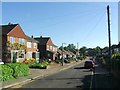
![Canterbury houses [76]](https://s3.geograph.org.uk/geophotos/07/08/97/7089779_df4deb83_120x120.jpg)
Canterbury houses [76]
Westgate Court, number 1 Linden Grove, is an 18th century house. Constructed of stuccoed brick under a hipped tile roof. Listed, grade II, with details at: https://historicengland.org.uk/listing/the-list/list-entry/1240923
Canterbury is a small historic city on the River Stour in Kent, some 54 miles southeast of London. Occupied since prehistoric times, it became an important Roman city. In 672, the see of Canterbury gained authority over the entire English Church. After the murder of Archbishop Thomas Becket at the cathedral in 1170, pilgrims from all parts of Christendom came to visit his shrine until the Dissolution. Today, Canterbury is a popular tourist destination and one of the most-visited cities in the United Kingdom. The city has a substantial student population, with four university campuses.
Image: © Michael Dibb
Taken: 6 Sep 2021
0.06 miles
7
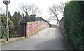
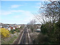
Whitehall Bridge, Canterbury
Railway bridge over the section of line between Canterbury West and Chartham.
Image: © pam fray
Taken: 29 Mar 2009
0.06 miles
9
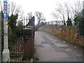
Whitehall Bridge, Canterbury
Railway bridge over the section of line between Canterbury West and Chartham.
The bridge is also used by National Cycle Route 1 (leading to Fordwich through Canterbury).
Image: © David Anstiss
Taken: 17 Feb 2014
0.06 miles
10
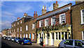
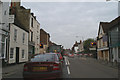
The Black Horse
Terraced local pub in Orchard Street
Image: © Des Blenkinsopp
Taken: 19 Aug 2011
0.06 miles