IMAGES TAKEN NEAR TO
Redwood Close, CANTERBURY, CT2 7TH
Introduction
This page details the photographs taken nearby to Redwood Close, CT2 7TH by members of the Geograph project.
The Geograph project started in 2005 with the aim of publishing, organising and preserving representative images for every square kilometre of Great Britain, Ireland and the Isle of Man.

There are currently over 7.5m images from over14,400 individuals and you can help contribute to the project by visiting https://www.geograph.org.uk
Image Map
Images are licensed for reuse under creativecommons.org/licenses/by-sa/2.0
Notes
- Clicking on the map will re-center to the selected point.
- The higher the marker number, the further away the image location is from the centre of the postcode.
Image Listing (58 Images Found)
Images are licensed for reuse under creativecommons.org/licenses/by-sa/2.0
Image
Details
Distance
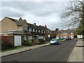
4
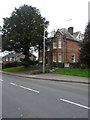
Looking SE along the Whitstable Road towards Canterbury
Image: © Nick Smith
Taken: 8 Apr 2008
0.13 miles

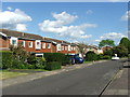
8
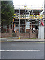
Wesley Manse, 71 Whitstable Road
Planning permission has been granted by Canterbury City Council under application number CA//15/02157 for the “alteration, extension and conversion of property to nine apartments”. One of the comments, relating to this application, referred to it as being a former HMO (health maintenance organisation), which originally was a large house and then became an old people's home. It bears a date-stone of 1902.
Image: © John Baker
Taken: 27 Dec 2015
0.16 miles
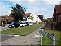
9

Junction of Harkness Drive with the A290 Whitstable Road
Image: © Nick Smith
Taken: 8 Apr 2008
0.16 miles
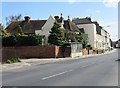
10
38, Whitstable Road
Planning permission has been granted by Canterbury City Council under application number CA//14/02295 for the “extension of existing dwelling and erection of four-unit apartment block”.
This image shows Image before any work started. It is referred to as the ‘existing dwelling’ in the planning application.
Image: © John Baker
Taken: 4 Feb 2018
0.17 miles