IMAGES TAKEN NEAR TO
Friary Way, CANTERBURY, CT2 7RL
Introduction
This page details the photographs taken nearby to Friary Way, CT2 7RL by members of the Geograph project.
The Geograph project started in 2005 with the aim of publishing, organising and preserving representative images for every square kilometre of Great Britain, Ireland and the Isle of Man.

There are currently over 7.5m images from over14,400 individuals and you can help contribute to the project by visiting https://www.geograph.org.uk
Image Map
Images are licensed for reuse under creativecommons.org/licenses/by-sa/2.0
Notes
- Clicking on the map will re-center to the selected point.
- The higher the marker number, the further away the image location is from the centre of the postcode.
Image Listing (24 Images Found)
Images are licensed for reuse under creativecommons.org/licenses/by-sa/2.0
Image
Details
Distance
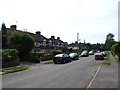
2

Junction of Harkness Drive with the A290 Whitstable Road
Image: © Nick Smith
Taken: 8 Apr 2008
0.10 miles
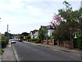
5
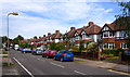
Looking SE along the Whitstable Road towards Canterbury
Image: © Nick Smith
Taken: 8 Apr 2008
0.12 miles
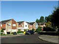
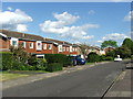
10
Harcourt Drive, Canterbury
At first glance these are your typical suburban semis, except they are blocks of four, with two terraced units in the centre of each block.
Image: © Des Blenkinsopp
Taken: 20 Aug 2011
0.19 miles