IMAGES TAKEN NEAR TO
St. Stephens Court, CANTERBURY, CT2 7JP
Introduction
This page details the photographs taken nearby to St. Stephens Court, CT2 7JP by members of the Geograph project.
The Geograph project started in 2005 with the aim of publishing, organising and preserving representative images for every square kilometre of Great Britain, Ireland and the Isle of Man.

There are currently over 7.5m images from over14,400 individuals and you can help contribute to the project by visiting https://www.geograph.org.uk
Image Map
Images are licensed for reuse under creativecommons.org/licenses/by-sa/2.0
Notes
- Clicking on the map will re-center to the selected point.
- The higher the marker number, the further away the image location is from the centre of the postcode.
Image Listing (145 Images Found)
Images are licensed for reuse under creativecommons.org/licenses/by-sa/2.0
Image
Details
Distance
1
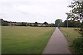
St. Stephen's Pathway, Canterbury
This path leads from St.Stephens Road, near Canterbury West Railway Station. It leads through St.Stephen's Playing field to St.Stephen's Green.
Image: © David Anstiss
Taken: 30 Sep 2009
0.05 miles
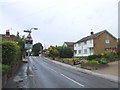
2
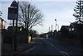
Approaching the level crossing, St Stephen's Rd
Image: © N Chadwick
Taken: 10 Dec 2011
0.06 miles
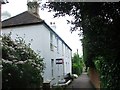
3
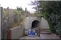
Hackington Place footpath under the railway
This footpath leads from St.Stephen's Pathway to St.Stephen's Road near Canterbury West Railway Station.
Image: © David Anstiss
Taken: 30 Sep 2009
0.08 miles
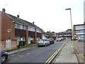
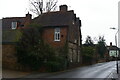
6
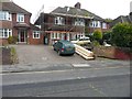
132, St Stephen's Road
It would appear that the house is undergoing renovation.
Image: © John Baker
Taken: 24 Nov 2013
0.10 miles
7
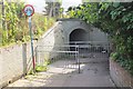
Railway underpass, Canterbury
On a cyclepath from central Canterbury to the St Stephen's district and the University of Kent.
Image: © Jim Barton
Taken: 25 Sep 2015
0.10 miles
8
Canterbury: house on St Stephen's Road
Dotted up St Stephen's Road are various older buildings now engulfed in twentieth-century suburbia.
Image: © Christopher Hilton
Taken: 26 Nov 2018
0.11 miles
9
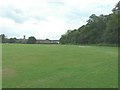
Beverley Meadow/St Stephen's playing field
The central tower of Canterbury Cathedral is visible in the distance, while on the right the line of tree hides an embankment that once carried The Canterbury to Whitstable Railway (nicknamed The Crab and Winkle). It was opened on 3 May 1830 with stations at Canterbury West and Whitstable Harbour only. Three further stations were opened during the 20th century at Blean and Tyler Hill Halt on 13 June 1908, South Street Halt on 1 July 1911 and Tankerton Halt on 1 July 1914. The railway was closed to passengers on 31 December 1930 and to all traffic on 1 December 1952. However, the following year it was reopened from 6-28 February to carry essential services from Canterbury to Whitstable, as a result of the severe coastal flooding that occurred along the east coast of the UK early in 1953.
Image: © John Baker
Taken: 23 Jun 2013
0.12 miles