IMAGES TAKEN NEAR TO
Roper Road, CANTERBURY, CT2 7EX
Introduction
This page details the photographs taken nearby to Roper Road, CT2 7EX by members of the Geograph project.
The Geograph project started in 2005 with the aim of publishing, organising and preserving representative images for every square kilometre of Great Britain, Ireland and the Isle of Man.

There are currently over 7.5m images from over14,400 individuals and you can help contribute to the project by visiting https://www.geograph.org.uk
Image Map
Images are licensed for reuse under creativecommons.org/licenses/by-sa/2.0
Notes
- Clicking on the map will re-center to the selected point.
- The higher the marker number, the further away the image location is from the centre of the postcode.
Image Listing (831 Images Found)
Images are licensed for reuse under creativecommons.org/licenses/by-sa/2.0
Image
Details
Distance
2
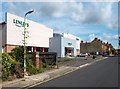
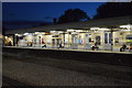
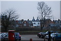
Lenleys Furniture Store
In Roper Road.
Image: © Des Blenkinsopp
Taken: 29 Aug 2011
0.04 miles
3
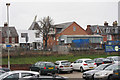
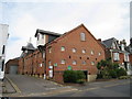
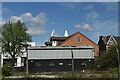
The Maltings, Roper Close, Canterbury, Kent
Image: © Oast House Archive
Taken: 12 Feb 2011
0.04 miles
6
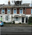
6, Roper Road
Planning permission has been granted by Canterbury City Council under application number CA/20/01573 for a “single-storey rear extension together with 1 dormer window to front elevation and 2 dormer windows to rear elevation for use of roof space as additional living accommodation”.
Image: © John Baker
Taken: 25 Oct 2020
0.06 miles
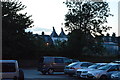
8
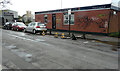
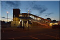
Kent Cars of Canterbury Ltd, Roper Road
The establishment is permanently closed.
Image: © John Baker
Taken: 25 Oct 2020
0.07 miles