IMAGES TAKEN NEAR TO
Roper Close, CANTERBURY, CT2 7EP
Introduction
This page details the photographs taken nearby to Roper Close, CT2 7EP by members of the Geograph project.
The Geograph project started in 2005 with the aim of publishing, organising and preserving representative images for every square kilometre of Great Britain, Ireland and the Isle of Man.

There are currently over 7.5m images from over14,400 individuals and you can help contribute to the project by visiting https://www.geograph.org.uk
Image Map
Images are licensed for reuse under creativecommons.org/licenses/by-sa/2.0
Notes
- Clicking on the map will re-center to the selected point.
- The higher the marker number, the further away the image location is from the centre of the postcode.
Image Listing (848 Images Found)
Images are licensed for reuse under creativecommons.org/licenses/by-sa/2.0
Image
Details
Distance
1
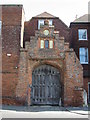
The Roper Gate, St Dunstan's Street
See http://www.geograph.org.uk/photo/778557 for details
Image: © Nick Smith
Taken: 26 Apr 2008
0.05 miles
3
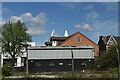
![Canterbury buildings [18]](https://s1.geograph.org.uk/geophotos/07/08/31/7083197_0531dc4d_120x120.jpg)
Canterbury buildings [18]
Roper House, number 34 St Dunstan's Street, was built in the mid 19th century in red brick under a slate roof. Today the house is a care home with emphasis on those with hearing loss.
Canterbury is a small historic city on the River Stour in Kent, some 54 miles southeast of London. Occupied since prehistoric times, it became an important Roman city. In 672, the see of Canterbury gained authority over the entire English Church. After the murder of Archbishop Thomas Becket at the cathedral in 1170, pilgrims from all parts of Christendom came to visit his shrine until the Dissolution. Today, Canterbury is a popular tourist destination and one of the most-visited cities in the United Kingdom. The city has a substantial student population, with four university campuses.
Image: © Michael Dibb
Taken: 5 Sep 2021
0.05 miles
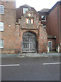
4
The Roper Gate
Grade II listed. http://www.britishlistedbuildings.co.uk/en-441032-the-roper-gate-kent#.WBjU6ySxewI
Image: © N Chadwick
Taken: 12 Feb 2016
0.05 miles
5
![Canterbury buildings [17]](https://s2.geograph.org.uk/geophotos/07/08/31/7083194_9eff4cd1_120x120.jpg)
Canterbury buildings [17]
Number 33 St Dunstan's Street is an early 19th century 3 storey industrial building in red brick. Attached to the left is a late 19th century matching range. At one time part of the Roper Brewery. Listed, grade II, with details at: https://historicengland.org.uk/listing/the-list/list-entry/1241791
Canterbury is a small historic city on the River Stour in Kent, some 54 miles southeast of London. Occupied since prehistoric times, it became an important Roman city. In 672, the see of Canterbury gained authority over the entire English Church. After the murder of Archbishop Thomas Becket at the cathedral in 1170, pilgrims from all parts of Christendom came to visit his shrine until the Dissolution. Today, Canterbury is a popular tourist destination and one of the most-visited cities in the United Kingdom. The city has a substantial student population, with four university campuses.
Image: © Michael Dibb
Taken: 5 Sep 2021
0.05 miles
6
Plaque on the wall for The Roper Gate
See http://www.geograph.org.uk/photo/778565 for the gateway itself.
Image: © Nick Smith
Taken: 26 Apr 2008
0.05 miles
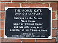
7
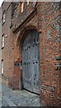
The Roper Gate, St Dunstan?s Street
The Roper Gate is a decorated 16th-century gateway that once provided an entrance to Place House, home of William Roper and his wife, Margaret Roper, daughter of Sir Thomas More. The gate is a wonderful example of decorative Tudor brickwork. Nothing now remains of Place House beyond the gateway.
The gate is a four-centred arch, surmounted by a stepped gable rising in five levels. The gable is pierced with a three-light window, above which is a small roundel window. The gateway is further decorated with diamond 'diapering'.
When More was executed for treason by Henry VIII, Margaret Roper was granted permission to take her father's head. This head she stored in the Roper family vault in St Dunstan's Church, just a few yards further along St Dunstan Street, where it became a destination for pilgrims, particularly following More's elevation to sainthood in 1935 http://www.britainexpress.com/attractions.htm?attraction=3358
Image: © John Baker
Taken: 4 Feb 2018
0.05 miles
9
6, Roper Road
Planning permission has been granted by Canterbury City Council under application number CA/20/01573 for a “single-storey rear extension together with 1 dormer window to front elevation and 2 dormer windows to rear elevation for use of roof space as additional living accommodation”.
Image: © John Baker
Taken: 25 Oct 2020
0.05 miles