IMAGES TAKEN NEAR TO
North Lane, CANTERBURY, CT2 7EF
Introduction
This page details the photographs taken nearby to North Lane, CT2 7EF by members of the Geograph project.
The Geograph project started in 2005 with the aim of publishing, organising and preserving representative images for every square kilometre of Great Britain, Ireland and the Isle of Man.

There are currently over 7.5m images from over14,400 individuals and you can help contribute to the project by visiting https://www.geograph.org.uk
Image Map (Loading...)


Getting Data...Please wait
Leaflet Map data © OpenStreetMap
Images are licensed for reuse under creativecommons.org/licenses/by-sa/2.0
Notes
- Clicking on the map will re-center to the selected point.
- The higher the marker number, the further away the image location is from the centre of the postcode.
Image Listing (1679 Images Found)
Images are licensed for reuse under creativecommons.org/licenses/by-sa/2.0
Image
Details
Distance
1
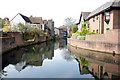
The Great Stour
A view looking upstream taken from the small pedestrian bridge across the river near "Miller's Field" carpark.
Image: © david mills
Taken: 22 Apr 2008
0.01 miles
2
Footbridge over the Great Stour, Canterbury
Image: © N Chadwick
Taken: 27 Sep 2008
0.01 miles
4
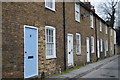
Terrace, Pound Lane
Grade II listed. http://www.britishlistedbuildings.co.uk/en-440825-7-12-pound-lane-kent
Image: © N Chadwick
Taken: 12 Feb 2016
0.01 miles
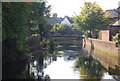
5
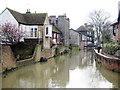
The Great Stour
River running between buildings on Pound Lane seen to left and North Lane to right. A footbridge linking Pound Lane and car park off North Lane can be seen ahead.
Image: © Oast House Archive
Taken: 12 Feb 2011
0.01 miles
6
Former tower fortification
Grade II listed. http://www.britishlistedbuildings.co.uk/en-440824-6-pound-lane-kent
Image: © N Chadwick
Taken: 12 Feb 2016
0.01 miles
7
Former tower fortification
Grade II listed. http://www.britishlistedbuildings.co.uk/en-440824-6-pound-lane-kent
Image: © N Chadwick
Taken: 12 Feb 2016
0.01 miles
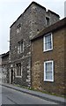
8
![Canterbury buildings [49]](https://s1.geograph.org.uk/geophotos/07/08/85/7088585_7a81c284_120x120.jpg)
Canterbury buildings [49]
Numbers 22 and 23 North Lane are a pair of 17th century houses now used as offices. Timber framed, the second floor jettied to the street, refronted in stuccoed brick in the early 19th century, all under an old tile roof. Listed, grade II, with details at: https://historicengland.org.uk/listing/the-list/list-entry/1241137
Canterbury is a small historic city on the River Stour in Kent, some 54 miles southeast of London. Occupied since prehistoric times, it became an important Roman city. In 672, the see of Canterbury gained authority over the entire English Church. After the murder of Archbishop Thomas Becket at the cathedral in 1170, pilgrims from all parts of Christendom came to visit his shrine until the Dissolution. Today, Canterbury is a popular tourist destination and one of the most-visited cities in the United Kingdom. The city has a substantial student population, with four university campuses.
Image: © Michael Dibb
Taken: 6 Sep 2021
0.02 miles
9
![Canterbury houses [73]](https://s2.geograph.org.uk/geophotos/07/08/86/7088650_565b5f8d_120x120.jpg)
Canterbury houses [73]
Number 49 North Lane is a 16th century timber framed building encased in red brick in the 18th century, under a hipped tile roof. Listed, grade II, with details at: https://historicengland.org.uk/listing/the-list/list-entry/1273525
Canterbury is a small historic city on the River Stour in Kent, some 54 miles southeast of London. Occupied since prehistoric times, it became an important Roman city. In 672, the see of Canterbury gained authority over the entire English Church. After the murder of Archbishop Thomas Becket at the cathedral in 1170, pilgrims from all parts of Christendom came to visit his shrine until the Dissolution. Today, Canterbury is a popular tourist destination and one of the most-visited cities in the United Kingdom. The city has a substantial student population, with four university campuses.
Image: © Michael Dibb
Taken: 6 Sep 2021
0.02 miles
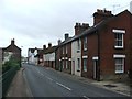
10
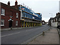
Looking north-northeast along North Lane
The frontages of the terrace, numbered 16-21, have had scaffolding and blue safety netting erected.
Image: © John Baker
Taken: 22 Nov 2015
0.02 miles