IMAGES TAKEN NEAR TO
The Fairway, HYTHE, CT21 6AU
Introduction
This page details the photographs taken nearby to The Fairway, CT21 6AU by members of the Geograph project.
The Geograph project started in 2005 with the aim of publishing, organising and preserving representative images for every square kilometre of Great Britain, Ireland and the Isle of Man.

There are currently over 7.5m images from over14,400 individuals and you can help contribute to the project by visiting https://www.geograph.org.uk
Image Map
Images are licensed for reuse under creativecommons.org/licenses/by-sa/2.0
Notes
- Clicking on the map will re-center to the selected point.
- The higher the marker number, the further away the image location is from the centre of the postcode.
Image Listing (208 Images Found)
Images are licensed for reuse under creativecommons.org/licenses/by-sa/2.0
Image
Details
Distance
1
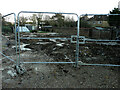
Building site, The Fairway
Planning permission has been approved, with conditions, by Folkestone and Hythe District Council under application number 21/1560/FH for the “demolition of existing two storey 5 bedroom dwelling. New build 5 bedroom dwelling on existing footprint, using existing massing and form to inform design”.
The house, which once stood on the site, was called Harmony.
Image: © John Baker
Taken: 28 Nov 2021
0.02 miles
3
Porters View, South Road
This was the Image Access to the property now appears to be from South Road.
Image: © John Baker
Taken: 5 Aug 2019
0.04 miles
4
Building site, The Fairway
Viewed from South Road, planning permission has been approved, with conditions, by Folkestone and Hythe District Council under application number Y16/0587/SH for the “erection of a block of three flats (2 x two bedroom apartments and 1 x three bedroom[s]) together with associated parking and amenity space”.
The flats are to be erected in the former garden of Moyle Cottage, which is the house beyond the site. The Fairway is a cul-de-sac, which runs along the right side of the site.
Now that construction has been completed, the flats are located in a building called Image
Image: © John Baker
Taken: 13 Jul 2018
0.05 miles
5
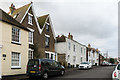
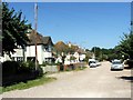
Stade Street
Early 19th Century housing in Stade Street.
Image: © Ian Capper
Taken: 16 Jan 2017
0.05 miles
6
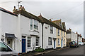
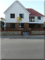
110 - 114 Stade Street
Early 19th Century housing in Stade Street. Both buildings are grade II listed - for no 114 (with the blue door) see www.historicengland.org.uk/listing/the-list/list-entry/1068926 and for nos 110 - 112 (beyond) see www.historicengland.org.uk/listing/the-list/list-entry/1344129.
Image: © Ian Capper
Taken: 16 Jan 2017
0.05 miles
9
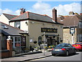
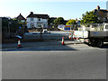
The Hope Inn, Hythe
Public House on junction of 82 Stade Street (in front) and Albert Lane (on right, going behind pub).
Image: © David Anstiss
Taken: 25 Apr 2009
0.08 miles
10
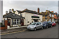
The Hope Inn
Early 19th Century pub in Stade Street.
Image: © Ian Capper
Taken: 16 Jan 2017
0.08 miles