IMAGES TAKEN NEAR TO
Prospect Road, HYTHE, CT21 5NS
Introduction
This page details the photographs taken nearby to Prospect Road, CT21 5NS by members of the Geograph project.
The Geograph project started in 2005 with the aim of publishing, organising and preserving representative images for every square kilometre of Great Britain, Ireland and the Isle of Man.

There are currently over 7.5m images from over14,400 individuals and you can help contribute to the project by visiting https://www.geograph.org.uk
Image Map
Images are licensed for reuse under creativecommons.org/licenses/by-sa/2.0
Notes
- Clicking on the map will re-center to the selected point.
- The higher the marker number, the further away the image location is from the centre of the postcode.
Image Listing (494 Images Found)
Images are licensed for reuse under creativecommons.org/licenses/by-sa/2.0
Image
Details
Distance
2
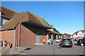
Aldi, Hythe
Ugly supermarket building by Bank Street.
Image: © Oast House Archive
Taken: 19 Mar 2011
0.03 miles
3
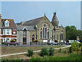
St. Michael's Methodist - Anglican Church Centre, Hythe
Formerly just a Methodist church.
Image: © Robin Webster
Taken: 13 Jul 2013
0.03 miles
5
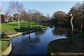
Hythe: The Royal Military Canal 2 from Stade Street bridge
Image: © Michael Garlick
Taken: 17 Jan 2017
0.03 miles
6
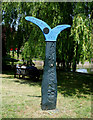
Cycle Network Sign
This attractive sign is by the bridge over the river in Stade Street.
Image: © terry joyce
Taken: 22 Jun 2010
0.03 miles
7
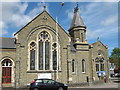
Hythe Methodist Church
On A259 Rampart Road.
Image: © David Anstiss
Taken: 25 Apr 2009
0.03 miles
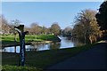
9
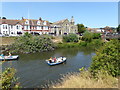
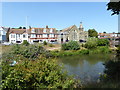
Looking across the Royal Military Canal
The Royal Military Canal was built between 1804 and 1809 as a response to the threat of a Napoleonic invasion. At its peak there were 1,500 men working on the canal. The canal was dug entirely by hand, using picks and shovels and the soil was carried away in wheelbarrows. It runs for 28 miles between Seabrook near Folkestone and Cliff End near Hastings, and follows the old cliff line bordering Romney Marsh. Artillery batteries were generally located every 500 yards where the canal was staggered to create a salient, allowing the guns to cover the next stretch of water. A military road was built on the inland side of the canal, and crossings consisted of moveable wooden bridges. The Military Road still follows the inland side of the Canal.
Although it was never called into action, the canal was fortified with concrete pillboxes during the early stages of the Second World War, when a German invasion was looking likely. Only three of these now remain.
Its other original purpose was to act as a major drainage system for the winter, and a reservoir for the summer and so greatly improve conditions on Romney Marsh. It still does this today as the Environment Agency uses the waterway to manage water levels on Romney Marsh and Walland Marsh.
In Hythe it provides an amenity as seen here on the hottest day of the year. Hythe Methodist Church can be seen on the opposite bank.
Image: © Marathon
Taken: 8 Jul 2018
0.03 miles
10
Looking across the Royal Military Canal
The Royal Military Canal was built between 1804 and 1809 as a response to the threat of a Napoleonic invasion. At its peak there were 1,500 men working on the canal. The canal was dug entirely by hand, using picks and shovels and the soil was carried away in wheelbarrows. It runs for 28 miles between Seabrook near Folkestone and Cliff End near Hastings, and follows the old cliff line bordering Romney Marsh. Artillery batteries were generally located every 500 yards where the canal was staggered to create a salient, allowing the guns to cover the next stretch of water. A military road was built on the inland side of the canal, and crossings consisted of moveable wooden bridges. The Military Road still follows the inland side of the Canal.
Although it was never called into action, the canal was fortified with concrete pillboxes during the early stages of the Second World War, when a German invasion was looking likely. Only three of these now remain.
Its other original purpose was to act as a major drainage system for the winter, and a reservoir for the summer and so greatly improve conditions on Romney Marsh. It still does this today as the Environment Agency uses the waterway to manage water levels on Romney Marsh and Walland Marsh.
In Hythe it provides an amenity as seen here on the hottest day of the year. Hythe Methodist Church in Rampart Road can be seen on the opposite bank.
Image: © Marathon
Taken: 8 Jul 2018
0.03 miles