IMAGES TAKEN NEAR TO
Castle Road, HYTHE, CT21 5EY
Introduction
This page details the photographs taken nearby to Castle Road, CT21 5EY by members of the Geograph project.
The Geograph project started in 2005 with the aim of publishing, organising and preserving representative images for every square kilometre of Great Britain, Ireland and the Isle of Man.

There are currently over 7.5m images from over14,400 individuals and you can help contribute to the project by visiting https://www.geograph.org.uk
Image Map
Images are licensed for reuse under creativecommons.org/licenses/by-sa/2.0
Notes
- Clicking on the map will re-center to the selected point.
- The higher the marker number, the further away the image location is from the centre of the postcode.
Image Listing (299 Images Found)
Images are licensed for reuse under creativecommons.org/licenses/by-sa/2.0
Image
Details
Distance
1

View From Castle Road, Hythe, Kent
View from near the top of the hill, looking over the town and towards the sea in the direction of Dymchurch.
Image: © Peter Trimming
Taken: 17 Jun 2009
0.04 miles
2
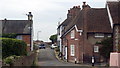
North Road, Hythe, Kent
Looking towards the west, with Castle Road on the right, and Church Hill on the left.
Image: © Peter Trimming
Taken: 17 Jun 2009
0.04 miles
3
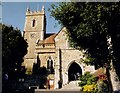
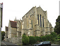
St Leonard, Hythe
Erected in the 12th century.
Image: © Michael FORD
Taken: Unknown
0.05 miles
5
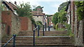
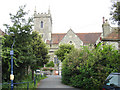
Church Hill, Hythe, Kent
Looking up the hill from near the bottom. A little research suggests that Church Hill was always a path, rather than a road.
Image: © Peter Trimming
Taken: 17 Jun 2009
0.05 miles
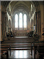
7
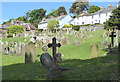
St. Leonard's churchyard, Hythe
The church was founded soon after the Norman invasion but it has changed and grown over the centuries. Looking towards North Road.
Image: © pam fray
Taken: 21 May 2017
0.06 miles
9
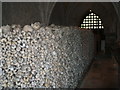
Ossuary in the crypt of St Leonard?s Church
The ossuary in the crypt of St Leonard‘s Church is one of only two in England (the other being in Rothwell, Northants) and contains 2,000 human skulls, 8,000 thighbones, a few jaw bones and various other artefacts. The skull and thighbones were usually kept as it was believed that it would ensure physical resurrection.
Image: © Clive Thompson
Taken: 12 May 2006
0.06 miles
10
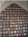
Ossuary in the crypt of St Leonard?s Church
These skulls are part of the ossuary in the crypt of St Leonard‘s Church containing 2,000 human skulls, 8,000 thighbones, a few jaw bones and various other artefacts. The exact origin of the bones is unclear, legend has it that they are the remains of Saxon soldiers killed in a battle fought nearby that were dug up when the existing church was built in 1080. A more likely explanation is that they were dug up and stored in the Middle Ages when it was customary to re-use burial plots.
Image: © Clive Thompson
Taken: 12 May 2006
0.06 miles