IMAGES TAKEN NEAR TO
Sandling Road, HYTHE, CT21 4HJ
Introduction
This page details the photographs taken nearby to Sandling Road, CT21 4HJ by members of the Geograph project.
The Geograph project started in 2005 with the aim of publishing, organising and preserving representative images for every square kilometre of Great Britain, Ireland and the Isle of Man.

There are currently over 7.5m images from over14,400 individuals and you can help contribute to the project by visiting https://www.geograph.org.uk
Image Map
Images are licensed for reuse under creativecommons.org/licenses/by-sa/2.0
Notes
- Clicking on the map will re-center to the selected point.
- The higher the marker number, the further away the image location is from the centre of the postcode.
Image Listing (21 Images Found)
Images are licensed for reuse under creativecommons.org/licenses/by-sa/2.0
Image
Details
Distance
1
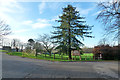
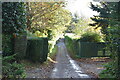
Entrance to Brockhill Country Park
The car park is down a fairly long drive to the right. On the left is a school.
Image: © Robin Webster
Taken: 28 Dec 2015
0.10 miles
2
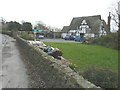
Creation of an annex at Sandtiles, Sandling Road
Planning permission has been approved, with conditions, by Folkestone and Hythe District Council under application number Y13/0734/SH for “alterations to existing garage to create a two storey annex building”.
Image: © John Baker
Taken: 2 Mar 2014
0.17 miles
3
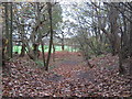
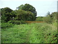
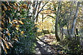
Saxon Shore Way in Heane Wood
The long distance path leads from Stone Farm, through the wood, towards to Pedlinge Farm on Hythe Road.
Image: © David Anstiss
Taken: 13 Nov 2010
0.19 miles
4
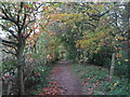
Footpath junction near Sandling Station
The Saxon Shore Way (long distance path) heads to Stone Farm through Heane Wood (via a bridleway) on the right. It also heads left on a footpath towards Pedlinge.
Image: © David Anstiss
Taken: 13 Nov 2010
0.21 miles
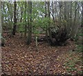
5
By Willow Wood
The Saxon Shore Way beside Willow Wood, near Sandling.
Image: © Chris Heaton
Taken: 13 Sep 2010
0.21 miles
7
Footpath to Sandsling Station (2)
A footpath leads from Rectory Lane beside the dismantled Hythe and Sandgate railway (hidden on the right, in the trees) to Sandling Station on Sandling Road
Image: © David Anstiss
Taken: 13 Nov 2010
0.21 miles
10
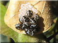
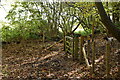
Insect larvae with egg cases
Spotted these on the underside of a field maple leaf (Acer campestre) whilst waiting for the queue for a car parking ticket in the car park next to Image
Image: © Andy Potter
Taken: 31 Aug 2009
0.22 miles