IMAGES TAKEN NEAR TO
Admiral Drive, HYTHE, CT21 4AX
Introduction
This page details the photographs taken nearby to Admiral Drive, CT21 4AX by members of the Geograph project.
The Geograph project started in 2005 with the aim of publishing, organising and preserving representative images for every square kilometre of Great Britain, Ireland and the Isle of Man.

There are currently over 7.5m images from over14,400 individuals and you can help contribute to the project by visiting https://www.geograph.org.uk
Image Map
Images are licensed for reuse under creativecommons.org/licenses/by-sa/2.0
Notes
- Clicking on the map will re-center to the selected point.
- The higher the marker number, the further away the image location is from the centre of the postcode.
Image Listing (78 Images Found)
Images are licensed for reuse under creativecommons.org/licenses/by-sa/2.0
Image
Details
Distance
1
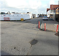
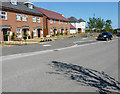
Admiral Drive
The road, part of the Martello Lakes Housing Development, describes a crescent with another Image junction a little further along Cornflower Avenue.
Planning permission was approved, with conditions, by Folkestone and Hythe District Council under application number Y06/1079/SH for the “outline application for mixed use development comprising residential development (1050 dwellings); employment development (use class B1, 15,000 sq.m); local centre (500 sq.m use classes A1/A2, 500 sq.m use classes A3/A4/A5); community centre /community facilities (1,000 sq.m use class D1); public open space (8.5 HA); structural open space (10.3 HA); retention and alteration of water bodies (retained area 15.5 HA); provision of two new access points to Dymchurch Road; and site restoration including raising of land levels”.
Image: © John Baker
Taken: 28 Oct 2018
0.01 miles
2
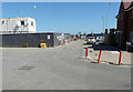
Admiral Drive
Admiral Drive is part of the Martello Lakes Housing Development.
Planning permission was approved, with conditions, by Folkestone and Hythe District Council under application number Y06/1079/SH for the “outline application for mixed use development comprising residential development (1050 dwellings); employment development (use class B1, 15,000 sq.m); local centre (500 sq.m use classes A1/A2, 500 sq.m use classes A3/A4/A5); community centre /community facilities (1,000 sq.m use class D1); public open space (8.5 HA); structural open space (10.3 HA); retention and alteration of water bodies (retained area 15.5 HA); provision of two new access points to Dymchurch Road; and site restoration including raising of land levels”. The location was given as Nickolls Quarry, Dymchurch Road, Hythe, Kent, CT21 4NE.
Image: © John Baker
Taken: 8 Jul 2018
0.02 miles
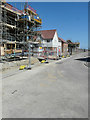
3
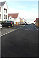
Castle View
The road is part of the Martello Lakes Housing Development and this is Image when these houses were being constructed.
Planning permission was approved, with conditions, by Folkestone and Hythe District Council under application number Y06/1079/SH for the “outline application for mixed use development comprising residential development (1050 dwellings); employment development (use class B1, 15,000 sq.m); local centre (500 sq.m use classes A1/A2, 500 sq.m use classes A3/A4/A5); community centre /community facilities (1,000 sq.m use class D1); public open space (8.5 HA); structural open space (10.3 HA); retention and alteration of water bodies (retained area 15.5 HA); provision of two new access points to Dymchurch Road; and site restoration including raising of land levels”.
Image: © John Baker
Taken: 28 Oct 2018
0.03 miles
4
Admiral Drive
The road, part of the Martello Lakes Housing Development, describes a crescent with the other Image junction a little further along Cornflower Avenue.
Planning permission was approved, with conditions, by Folkestone and Hythe District Council under application number Y06/1079/SH for the “outline application for mixed use development comprising residential development (1050 dwellings); employment development (use class B1, 15,000 sq.m); local centre (500 sq.m use classes A1/A2, 500 sq.m use classes A3/A4/A5); community centre /community facilities (1,000 sq.m use class D1); public open space (8.5 HA); structural open space (10.3 HA); retention and alteration of water bodies (retained area 15.5 HA); provision of two new access points to Dymchurch Road; and site restoration including raising of land levels”.
Image: © John Baker
Taken: 28 Oct 2018
0.04 miles
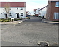
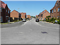
5
Castle View
The houses are being built on the Martello Lakes Housing Development and this is Image after these houses had been completed.
Planning permission was approved, with conditions, by Folkestone and Hythe District Council under application number Y06/1079/SH for the “outline application for mixed use development comprising residential development (1050 dwellings); employment development (use class B1, 15,000 sq.m); local centre (500 sq.m use classes A1/A2, 500 sq.m use classes A3/A4/A5); community centre /community facilities (1,000 sq.m use class D1); public open space (8.5 HA); structural open space (10.3 HA); retention and alteration of water bodies (retained area 15.5 HA); provision of two new access points to Dymchurch Road; and site restoration including raising of land levels”. The location was given as Nickolls Quarry, Dymchurch Road, Hythe, Kent, CT21 4NE.
Image: © John Baker
Taken: 8 Jul 2018
0.04 miles
6
Cornflower Avenue
This road is part of the Martello Lakes Housing Development.
Planning permission was approved, with conditions, by Folkestone and Hythe District Council under application number Y06/1079/SH for the “outline application for mixed use development comprising residential development (1050 dwellings); employment development (use class B1, 15,000 sq.m); local centre (500 sq.m use classes A1/A2, 500 sq.m use classes A3/A4/A5); community centre /community facilities (1,000 sq.m use class D1); public open space (8.5 HA); structural open space (10.3 HA); retention and alteration of water bodies (retained area 15.5 HA); provision of two new access points to Dymchurch Road; and site restoration including raising of land levels”. The location was given as Nickolls Quarry, Dymchurch Road, Hythe, Kent, CT21 4NE.
Image: © John Baker
Taken: 8 Jul 2018
0.05 miles
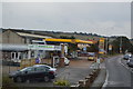
8

Jet Fuel Station
On Dymchurch Road at the entrance to Hythe.
Image: © Oast House Archive
Taken: 24 Jul 2010
0.07 miles
9
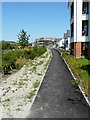
Path leading to Castle View
Castle View is part of the Martello Lakes Housing Development.
Planning permission was approved, with conditions, by Folkestone and Hythe District Council under application number Y06/1079/SH for the “outline application for mixed use development comprising residential development (1050 dwellings); employment development (use class B1, 15,000 sq.m); local centre (500 sq.m use classes A1/A2, 500 sq.m use classes A3/A4/A5); community centre /community facilities (1,000 sq.m use class D1); public open space (8.5 HA); structural open space (10.3 HA); retention and alteration of water bodies (retained area 15.5 HA); provision of two new access points to Dymchurch Road; and site restoration including raising of land levels”. The location was given as Nickolls Quarry, Dymchurch Road, Hythe, Kent, CT21 4NE.
I assume the building referred to in the road name is Lympne Castle.
Image: © John Baker
Taken: 8 Jul 2018
0.07 miles
10
Quarry Way
Here seen across Nickolls Road, Quarry Way is part of the Martello Lakes Housing Development.
Planning permission was approved, with conditions, by Folkestone and Hythe District Council under application number Y06/1079/SH for the “outline application for mixed use development comprising residential development (1050 dwellings); employment development (use class B1, 15,000 sq.m); local centre (500 sq.m use classes A1/A2, 500 sq.m use classes A3/A4/A5); community centre /community facilities (1,000 sq.m use class D1); public open space (8.5 HA); structural open space (10.3 HA); retention and alteration of water bodies (retained area 15.5 HA); provision of two new access points to Dymchurch Road; and site restoration including raising of land levels”. The location was given as Nickolls Quarry, Dymchurch Road, Hythe, Kent, CT21 4NE.
Image: © John Baker
Taken: 8 Jul 2018
0.07 miles